As we move into the fall season, winter and eventually spring, our weather patterns will ramp up at times. I constantly post updates on Facebook and Twitter. Please follow me on both sites, my Twitter handle is (@wxzachary) https://twitter.com/wxzachary?lang=en
Let's go over a few points.
- A few storms are possible late tonight, especially across NWA. Most of these storms should remain under severe limits, but don't be surprised if you wake up to some thunder or heavy rain.
- Temperatures and dew points ahead of the front will be warm and humid. By Sunday evening, there will be a noticeable drop in heat and humidity. Monday morning will be cool and dry, like Fall SHOULD be, Tuesday will be even cooler.
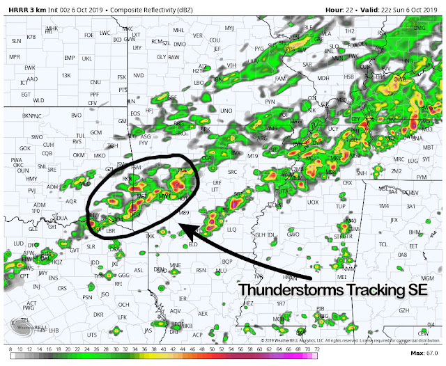
- I fully suspect the strongest storms to occur across western sections of Arkansas, from I-40 south toward the Arklatex. Warm daytime heating and viable moisture should allow for sustained thunderstorm development ahead of the front.
- While all modes of severe weather are possible, the main concern is damaging winds and larger hail. The tornado risk is not zero, but not high by any means.
I've included a few models to help paint a better picture.
If you've been following me for some time, you know I always like to include a model with the surface based CAPE values. I've done so here (model above this text). CAPE is essentially thunderstorm fuel, notice the higher values across southwest Arkansas, southeast Oklahoma and northeast Texas. This is due to warmer daytime heating and high moisture content. This combination is needed for sustained thunderstorm development.
By tomorrow afternoon it will be rather warm, especially across the southern half of Arkansas. You can clearly see the front positioned across northern Arkansas (50's and 60's) by tomorrow at lunch time. This won't last long, as the front will continue across the state during the span of Sunday evening.
By tomorrow afternoon, thunderstorms will be on-going across a fairly large part of the state. However, we will need to monitor the storms across southwest Arkansas as they form and track southeast. These are the storms I've been talking about in this blog and will pose the best threat for severe weather.
There could also be a few other clusters of stronger storms across southern Arkansas as well. As I spoke on earlier, damaging winds and larger hail seems to be the biggest concern. This is not uncommon for October and it appears we will have more chances for severe weather in the not so distant future.
Thank you so much for following and if you have any questions, feel free to comment or message!
-Zach


