
 |
| Tornado approaching Clinton (Van Buren County) during the evening hours of February 5th, 2008. Photo Credt: Josh Smith |
As the afternoon progressed a cold front approached the state from the west. This cooler air helped aid in thunderstorm development along the front. Thunderstorms became more widespread, storms began to rotate and unfortunately spawn tornadoes. Two notable tornadoes touched down, with one tracking for a dreadful 122 miles which is the longest tornado track on record, breaking the record set in 1950. In total, the state experienced 12 tornadoes throughout this day. However, most of these were generally short lived and weak.
 |
| Radar velocity scan portraying strong rotation just east of Hector (Pope County). |
 |
| Tornado track (122 miles) from Yell County - stretching northeast to Sharp County. |
The starting point of this deadly tornado was 5.6 miles east-southeast of Centerville. Eventually, this tornado finally dissipated just northeast of Highland in Sharp County. The rating for the tornado was initially at least an EF-3. According to the National Weather Service in Little Rock: "a member of a Quick Response Team (QRT) visited Arkansas on the 8th to look at some of the worst damage along the track. In the end, the rating was upgraded to EF4."
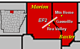 |
| Tornado track through Baxter and Marion County |
 |
| The cold front responsible for these strong storms eventually moving east |
We want to give a HUGE thank you to the National Weather Service in Little Rock for providing such valuable information regarding this weather event. We love creating these historic weather blogs, but could not do it without them. We hope you enjoyed this blog, and learned a little something while reading it.
-AW Team
References and information credits: https://www.weather.gov/ (NWS Little Rock)
We have also included the local storm reports from this day from the National Weather Service posted below. After looking at this report, one can agree that this was certainly one long day of severe weather.
000
NWUS54 KLZK 060413
LSRLZK

PRELIMINARY LOCAL STORM REPORT...SUMMARY
NATIONAL WEATHER SERVICE LITTLE ROCK AR
REPORTS FOR FEBRUARY 05 2008

..TIME...   ...EVENT...      ...CITY LOCATION...     ...LAT.LON...
..DATE...   ....MAG....      ..COUNTY LOCATION..ST.. ...SOURCE....
            ..REMARKS..

0215 PM     HAIL             CLARKSVILLE             35.46N 93.47W
02/05/2008  E1.00 INCH       JOHNSON            AR   LAW ENFORCEMENT

0220 PM     HAIL             LUDWIG                  35.35N 93.43W
02/05/2008  E1.00 INCH       LOGAN              AR   TRAINED SPOTTER

0240 PM     HAIL             TILLY                   35.72N 92.83W
02/05/2008  E0.75 INCH       POPE               AR   LAW ENFORCEMENT

0300 PM     HAIL             PINDALL                 36.06N 92.87W
02/05/2008  E0.75 INCH       SEARCY             AR   LAW ENFORCEMENT

            WIND ESTIMATED AT 60 MPH.

0415 PM     HAIL             HON                     34.93N 94.18W
02/05/2008  E1.75 INCH       SCOTT              AR   LAW ENFORCEMENT

0500 PM     TORNADO          N OLA                   35.03N 93.22W
02/05/2008                   YELL               AR   TRAINED SPOTTER

            TORNADO ON THE NORTH SIDE OF OLA. TREE LIMBS DOWN AND A
            BARN DAMAGED.

0502 PM     TORNADO          ATKINS                  35.24N 92.95W
02/05/2008                   POPE               AR   AMATEUR RADIO

            *** 3 FATAL *** UPDATE TO PREVIOUS REPORT.

0502 PM     HAIL             ATKINS                  35.24N 92.95W
02/05/2008  E0.75 INCH       POPE               AR   AMATEUR RADIO

            HWY 105 AND I-40

0502 PM     TORNADO          ATKINS                  35.24N 92.95W
02/05/2008                   POPE               AR   AMATEUR RADIO

            HWY 105 AND I-40

0510 PM     TSTM WND DMG     CARDEN BOTTOMS          35.15N 93.01W
02/05/2008                   YELL               AR   AMATEUR RADIO

            TREES DOWN IN CARDEN BOTTOMS. DAMAGE TO TWO STRUCTURES.

0515 PM     TORNADO          GASSVILLE               36.28N 92.49W
02/05/2008                   BAXTER             AR   BROADCAST MEDIA

            MOBILE HOME PARK DAMAGED. POWER POLES BLOCKING ROAD
            THROUGH TOWN.

0516 PM     TORNADO          CLEVELAND               35.42N 92.71W
02/05/2008                   CONWAY             AR   AMATEUR RADIO

            DEBRIS IN AIR

0516 PM     TORNADO          GASSVILLE               36.28N 92.49W
02/05/2008                   BAXTER             AR   TRAINED SPOTTER

            SPOTTERS REPORTED A TORNADO MOVING AWAY FROM GASSVILLE
            TOWARD MOUNTAIN HOME.

0516 PM     TORNADO          1 N WONDERVIEW          35.33N 92.73W
02/05/2008                   CONWAY             AR   TRAINED SPOTTER

            A TORNADO WAS REPORTED ON THE GROUND NORTH OF WONDERVIEW.


0521 PM     TORNADO          CLEVELAND               35.42N 92.71W
02/05/2008                   CONWAY             AR   AMATEUR RADIO

            TORNADO ON HWY 124 E OF CLEVELAND.

0521 PM     HAIL             CLEVELAND               35.42N 92.71W
02/05/2008  E0.75 INCH       CONWAY             AR   AMATEUR RADIO

0541 PM     TORNADO          CLINTON                 35.58N 92.45W
02/05/2008                   VAN BUREN          AR   AMATEUR RADIO

            TORNADO ON THE GROUND NEAR WAL-MART.

0542 PM     TORNADO          CLINTON                 35.58N 92.45W
02/05/2008                   VAN BUREN          AR   TRAINED SPOTTER

            SPOTTER WATCHING TORNADO IN TOWN OF CLINTON

0620 PM     TORNADO          MOUNTAIN VIEW           35.87N 92.11W
02/05/2008                   STONE              AR   AMATEUR RADIO

            HOSPITAL HIT BY TORNADO. EMERGENCY ROOM CLOSED.

0624 PM     HAIL             3 S SLOVAK              34.61N 91.58W
02/05/2008  E1.75 INCH       PRAIRIE            AR   AMATEUR RADIO

            GOLF BALL HAIL AT STUTTGART AIRPORT.

0625 PM     HAIL             5 NE SHERIDAN           34.36N 92.34W
02/05/2008  E1.75 INCH       GRANT              AR   EMERGENCY MNGR

            GOLF BALL HAIL BETWEEN SHERIDAN AND REDFIELD.

0630 PM     TORNADO          S MYRON                 36.18N 91.71W
02/05/2008                   IZARD              AR   TRAINED SPOTTER

            TREES BLOCKING COUNTY ROAD 69. 1/2 MILE WIDE DAMAGE PATH.


0650 PM     HAIL             SPARKMAN                33.92N 92.85W
02/05/2008  E0.75 INCH       DALLAS             AR   AMATEUR RADIO

0655 PM     TORNADO          E ASH FLAT              36.23N 91.61W
02/05/2008                   SHARP              AR   LAW ENFORCEMENT

            TORNADO ON HWY 354 EAST OF ASH FLAT. HOMES DAMAGED.

0700 PM     TSTM WND DMG     5 SW DOWNTOWN LITTLE RO 34.68N 92.30W
02/05/2008                   PULASKI            AR   BROADCAST MEDIA

            NUMEROUS TREES AND POWERLINES DOWN IN LITTLE ROCK. ROOF
            DAMAGED TO A NUMBER OF HOMES BY FALLEN TREES.

0700 PM     TORNADO          HIGHLAND                36.26N 91.52W
02/05/2008                   SHARP              AR   LAW ENFORCEMENT

            HIGHLAND FIRE DEPT. DESTROYED

0700 PM     TORNADO          S ASH FLAT              36.23N 91.61W
02/05/2008                   SHARP              AR   TRAINED SPOTTER

            167 S OF ASH FLAT CLOSED. TREES AND POWER LINES DOWN
            ACROSS THE COUNTY.

0713 PM     TSTM WND GST     LITTLE ROCK NATIONAL AI 34.73N 92.22W
02/05/2008  M67.00 MPH       PULASKI            AR   ASOS

0717 PM     TSTM WND GST     LITTLE ROCK AIR FORCE B 34.92N 92.15W
02/05/2008  M59.00 MPH       PULASKI            AR   OFFICIAL NWS OBS

0720 PM     TSTM WND DMG     FLORAL                  35.59N 91.76W
02/05/2008                   INDEPENDENCE       AR   PUBLIC

            CHICKEN HOUSE DESTROYED.

0730 PM     TSTM WND DMG     CABOT                   34.97N 92.02W
02/05/2008                   LONOKE             AR   COUNTY OFFICIAL

            TREES DOWN AND POWER OUT IN CABOT.

0843 PM     HAIL             S DE WITT               34.29N 91.34W
02/05/2008  E0.75 INCH       ARKANSAS           AR   LAW ENFORCEMENT

            POSSIBLE TORNADO JUST SOUTH OF DE WITT.
|


