Tuesday, February 27, 2018

Mid-Week Severe Weather - More Flooding Possible

Although the break from rainfall was much appreciated and very enjoyable, it is short lived. This week features a mid-week storm system that will bring more heavy rainfall and thunderstorms. Some of the thunderstorms mentioned could also hold severe potential, mainly across southern Arkansas. We will have all the details pertaining to flood potential and storms below. If you live in areas across southern Arkansas please continue to read, we have important information regarding placement and timing.

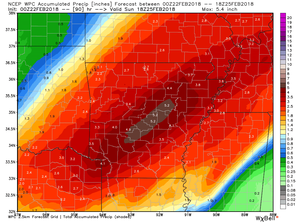
  • We DO NOT need rain right now, our soil is still very saturated from the heavy rains we just experienced. Preliminary models are suggesting parts of Arkansas could see over five inches of rain in the next 7-days.
  • Rain and storms will move in later this afternoon, we are not anticipating any severe weather today. The rain that does move in today will hang around through Wednesday and eventually move out mid-day Thursday.
  • There is a chance for strong to severe storms on Wednesday. Right now, the best chances for any severe weather looks to be in the late hours, moving into early Thursday morning.
  • All modes of severe weather are possible, but our main concern is damaging winds. Remember, you do not need a tornado to cause significant damage. Parts of Arkansas experienced this last year with straight line winds exceeding 100 mph in areas.
  • Some thunderstorms could develop tomorrow morning into the afternoon, but instability is limited. The main severe threat exists later Wednesday, into early Thursday.
  • Current model guidance suggests the best chances for severe weather exists mainly south of I-40, especially southeast Arkansas.   

You may ask, what is the culprit for the severe weather chances this week? A deep upper-level trough is forecast to progress across the Rocky Mountains Wednesday, along with southwesterly flow aloft. Dew-points will elevate into the mid to high 60's Wednesday afternoon. At surface level, a sharp cold front will progress east into Arkansas late Wednesday into the early Thursday morning. Thunderstorms will spark along this front, due to the dew point levels the atmosphere should remain unstable until the cold gradient of air overrides the warm air. 


For now, a "Slight" risk area has been issued for mainly southern Arkansas Wednesday. The reason for the small area is due to instability being mostly prevalent across the southern area of the state. Other locations could certainly see thunderstorms, however those storms SHOULD remain under severe limits.


Temperatures will warm into the 70's across southern Arkansas Wednesday afternoon. Temperatures will remain warm until the cool air eventually progresses east. These warm temperatures and moderate dew point levels will aid in day-time convection and instability. 

NAM 3 km simulated radar
The state will see rainfall for a large amount of time on Tuesday and Wednesday. However, the time to watch for severe development will be likely after 10 PM or so Wednesday night. Notice the line of storms we have circled here on simulated radar. Late Wednesday night we are expecting a group of stronger singular cell storms, or a linear complex of storms. These storms will ride the boundary of the cold front, and eventually move east out of the state. 

NAM 3 km simulated radar
By early Thursday morning storms are STILL going on for a large part of the state. However, the severe risk will be diminished at this time. All the storms and heavy rainfall should be out of the state completely by around noon Thursday. 

168 HR QPF
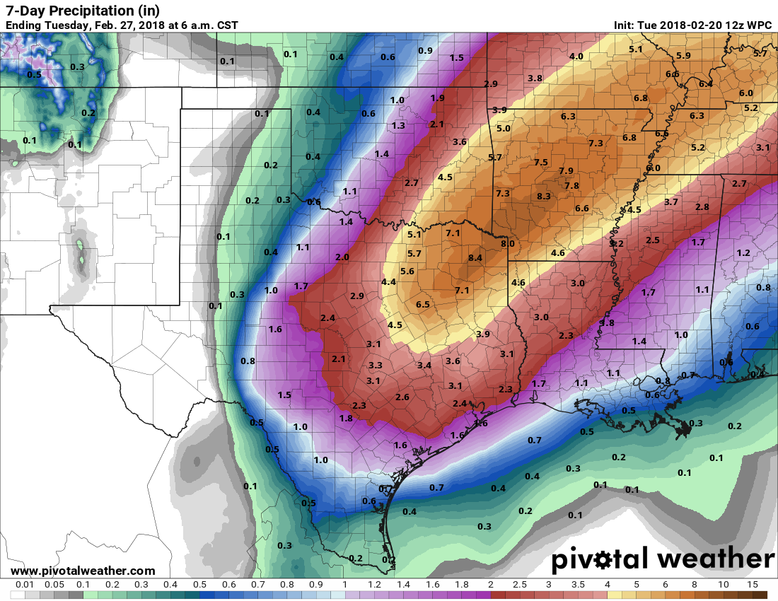
How about those rainfall totals for the next 7 days? Model guidance suggest we could see another 4-5 inches of rain in some areas in the next 7-days. With some spots possibly seeing near 6 inches, mainly across eastern Arkansas. This could cause further flooding issues and must be watched accordingly. 

After the next few days, we will luckily get a break from rainfall as an area of high-pressure will settle over the central portion of the nation. This will contribute to clear and fair skies, giving us some much needed sunshine. Rain chances do look to return early next week, we will have more on that later. Remember to have a severe weather plan ready for Wednesday night, since storms could occur late at night have a way to receive warnings! 

-AW Team 

Model Credits: http://www.pivotalweather.com/ - http://www.noaa.gov/ - http://models.weatherbell.com/


Saturday, February 24, 2018

Potentially Dangerous Severe Weather

To precursor this blog post, our goal is to never scare anyone, nor is to implement fear among our followers. We are not in the business of fear mongering, or causing shock and panic to gain viewers or a new following. However, with this being said, today is one of those days we are all too familiar with. Dangerous severe weather is possible today in parts of the state, if you are in the areas we speak of, have a plan ready. Don't panic, just be mindful of the situation and have an action plan for you and your family if severe weather were to threaten your area. Also, we don't normally post several blogs in a short span of time. With the imminent threat of severe weather, we take these events serious and want you to be well aware, so please take the time to read the following information.

We've just recently scanned over the newest high-resolution data, nothing has changed in our opinion. The warm front is currently lifting north, temperatures will begin to rise throughout the afternoon. We will see temps in the 60's and 70's throughout the day, making it feel very Spring like. The cold front that will initiate the severe weather today will gradually track east, cooling the atmosphere down once it passes. Portions of NWA will be in the high 30's to low 40's late tonight once the cold front  has made it's trek east.

Southern, eastern, and portions of central Arkansas has the highest chances for severe weather today. Western, and portions of northern Arkansas could certainly see storm development today. However, if you refer to our latest blog post, we discussed the energy potential is MUCH greater the further south you travel. We hope this clears up any confusion today regarding the threat. A good rule of thumb is expect stronger storms, and have a plan ready. Our target area is all of southern Arkansas, areas across central, and eastern, Arkansas.


First and foremost, we all know everyone wishes to know the exact timing the storms will enter your area. We cannot tell you pinpoint the exact location and time, we can however give you an estimate. We apologize for the graphic posted above, we know it is not fancy, but with time constraints it will do for a quick blog. We posted the time stamps on a county labeled map to avoid any confusion, just look for your county and match the time stamps on the graphic. The reason for the separation of time is due to the front possibly moving slower, or faster, than expected. You must account for all variables in a situation such as this.


The latest high-resolution data has suggested a large group of individual cells could form pre-frontal in the late morning hours. These individual cells will hold a higher potential to become super cellular and become very strong. However, the CAPE in this area is somewhat limited. Hopefully, this will help diminish the threat, but it must be watched VERY closely. We've circled the area of cells we are speaking of in the model above.

By 4 PM the storms appear to take a more complex and grouped structure, this large complex of storms will still be very powerful as it tracks east. Notice by this time portions of western Arkansas are beginning to clear away as the storms move eastward. 

High-resolution models then place the now linear complex of storms into parts of northeast, central, and south central Arkansas around 7 PM. This will be a large "squall-line" storm front. The tornado threat could become lower due to this, however with plenty of lift, and instability present, it could develop a few stronger tornadoes along the leading edge. The damaging wind risk will be fairly high with these storms, winds could easily exceed 70+ MPH along the frontal zone. 

Lastly, the storms will begin to exit the state late tonight around the midnight hour. Cloud clover will begin to depart and temperatures will gradually cool off as the cold front continues eastward. 

All modes of severe weather are possible today, damaging winds and tornadoes (a few possibly stronger) are our biggest concerns. Another big concern is the saturated grounds we are currently dealing with, especially across central, southwest, and northeast Arkansas. Large trees could easily become uprooted due to high winds tonight, this could cause hazardous conditions tonight across roadways. This storm will also dump plenty of rainfall, this will only agitate the flooding issue we are already experiencing. 

We will have updates throughout the day and post warnings accordingly. Please pay close attention to our Facebook page if you have no way of receiving warnings. We fully expect a tornado watch to be issued for portions of Arkansas today, we will advise of this when it becomes apparent. 

-AW Team

Model credits: http://models.weatherbell.com/

Friday, February 23, 2018

Severe Weather Saturday - Damaging Winds & Tornadoes

Well, it's about that time again--severe season is slowly approaching. Strong to severe storms are not uncommon in the months of January of February. Saturday looks like our next best chance for strong/severe storms. In this blog we will dive into detail giving you placement, timing, and aspects of the storms we can expect. If you do not have a severe weather plan in place, you need to establish one now--protect your life & property.

  • Flooding is still a major issue. It has continuously rained and will continue to do so. Remember to be mindful of flooding on roadways, as it will only get worse. Sunday looks like our first break from widespread rainfall.
  • The severe weather threat is focused on portions of southern, central, and eastern, Arkansas for Saturday. The primary threat hours will be mid-day for southwest Arkansas, and then the afternoon to evening hours for central and eastern Arkansas. 
  • Storms will hold a west to east track, slowly tracking across the state and finally exiting the state to the east early Sunday morning.
  • There is a severe potential with these storms, mostly a damaging wind and isolated tornado risk. The tornado threat is a little higher than what we usually see, we will explain further below.
  • Ahead of the storms temperatures will be warm, in the low to mid 70's across the southeast half of the state. This will help aid in much needed daytime heating for storm development.
As the day begins Saturday, cold air in place will begin to retreat north as a warm front nudges northwards. Southerly winds will push much needed moisture rich air from the Gulf into the state setting the stage for the afternoon hours. The atmosphere will be heavily saturated, dew points will stretch to near 70 across portions of eastern Arkansas. Current model guidance suggests minor breaks in cloud cover, which would only assist in daytime convection. As the cold front progresses east, strong storms will develop along the frontal zone. 


The Storm Prediction Center in Norman, Oklahoma has issued their outlook regarding Saturday storms. A large portion of central, southern, and eastern Arkansas is under an "ENHANCED" risk area, while other areas are under a "SLIGHT" risk. 

It will feel Spring like Saturday afternoon, notice the mid 70's across southeast Arkansas. These warm temperatures will assist in heating the atmosphere, aiding in instability for thunderstorm development.

There is more than plenty of instability available for this system, if cloud cover can break during Saturday this would become even more significant. Notice areas across eastern Arkansas are exceeding over 1,500 J/kg, more than plenty for late winter storms.

Storms will begin to initiate Saturday morning across western, and southwestern, Arkansas. Some of these could be stronger, but overall the severe potential is limited. 

Saturday evening the storms have really got their act together, storms could become more widespread in nature and more severe. If some of the cells involved become isolated, they will hold an even higher tornado threat. 

Later in the evening Saturday, around 9 PM, the storms are finally pushing through eastern Arkansas and out of the state completely in the early morning hours of Sunday. Notice how models try place the storms in a more linear style. However, even with simulated radar here you can see the cells still evolving into their own. 

With lift present, and current guidance showing the winds turning with height, rotation and therefore supercell development is certainly possible. Model guidance has suggest the possibility for tall updraft formation, with storms that could back-build well into the atmosphere, thus leading to strong storms. 

The grounds will already be heavily saturated due to the copious amounts of rainfall we have experienced. This will prove to be an issue as the storms will likely hold damaging winds, and even a tornado or two. Large trees could become uprooted and fall with ease, please keep this in mind. 

-AW Team

Models used are accredited to: http://models.weatherbell.com/ - http://www.noaa.gov/

Thursday, February 22, 2018

Saturday Severe Weather - Flooding Concern

Some areas have already received over four inches of rainfall in recent days, it appears we will see even MORE rainfall throughout the next few days. Luckily, we have dodged widespread severe weather lately, this could change on Saturday. We'll go into detail on that matter for this blog, we'll also discuss flooding potential, and who could see the most rainfall. Combined with the heavy rainfall we've experienced, some areas across northwest, and northern, Arkansas have also seen winter weather (freezing rain).

As a wave of low pressure moves east and southeast into this weekend, a strong area of storms is expected to develop Saturday afternoon. This could impact Arkansas in the same locations that have already seen copious amounts of heavy rainfall. At this current time, southeast Arkansas has the highest chances for more potent severe weather, this is obviously subject to change. This also DOES NOT mean other areas across the state will not see any severe weather. In fact, portions of central and southwest Arkansas could see some severe development Saturday.

A short wave in the mid-level atmosphere will slide through the upper level trough. A sub-tropical jet stream will help add a warm addition and needed moisture to the system. A warm front will nudge north and help surge warmer air from the Gulf, creating higher temperatures. Some storms will then build along the cold front into the evening and overnight as it progresses east.

Models representing thunderstorms, instability values, temperatures, and rainfall amounts are posted below. The text below each model, and or graphic, represents the respective model posted above it.


Warmer air will be present Saturday mid-day, notice mid 70's across southeast Arkansas. This warmer moist air will help aid in convection (day-time heating). Cloud cover does look to be present, which will help in limiting instability.


The Storm Prediction Center, based in Norman, Oklahoma has issued a Marginal and Slight risk area for portions of the state. The southeast portion of the state is our target area for severe weather, but as we've stated, other areas could see organized severe weather Saturday; thus the large slight risk area.


We have posted the NAM 12-KM instability values Saturday afternoon (CAPE). You have seen us use models representing CAPE before, this is basically the "fuel" for thunderstorm development - Convective Available Potential Energy. Notice the abundant instability across eastern and southeast Arkansas, thus the reason for our target area. Although the instability values round out at around 1200-1500 J/kg, in the late winter months higher CAPE values are not needed for sufficient storm development (compared to the Spring season).


More organized storms should begin to track east around noon Saturday, mainly across western Arkansas. A few isolated areas of showers across eastern Arkansas are possible throughout the day, but nothing organized. The real show will start Saturday evening, we've posted a future-cast model above, valid for Saturday evening around 9 PM. Notice how the storms are bunched in a more linear form, this should limit tornado potential. However, an isolated tornado or two are certainly possible; our main concern is more heavy rainfall, strong damaging winds, and hail.

We've posted a model representing accumulated precipitation through Sunday afternoon. Notice areas across central Arkansas could expect an additional five inches of rainfall. Some of these areas have already seen nearly five inches in the last several hours, this could aid in flooding potential due to heavily saturated grounds.

We will be monitoring Saturday throughout the next couple of days and have updates accordingly. The biggest story at this current time is by far the amount of rainfall, and flooding potential. It takes very little moving water to take a person off of their feet, this also includes vehicles. If you drive upon standing or moving water, TURN AROUND DO NOT DROWN.

We will likely have an additional blog post as we move closer to Saturday regarding the severe potential, stay tuned to our Facebook page and Twitter (@ARWeatherpage) as we provide updates.

-AW Team

All models used are accredited to: http://models.weatherbell.com/ - http://www.spc.noaa.gov/

Tuesday, February 20, 2018

Storms, Freezing Rain, and Flooding

We created a blog post a few days ago titled "Wild Week of Weather" - we weren't kidding either. We've experienced Spring like weather, rainfall, and thunderstorms. Guess what, it's only going to get more wild! With colder air moving in today, storms associated with the cold front, and some freezing rain possible, we felt a blog was needed to get everyone up to speed. Let's dig into some models and information.

Here is what you can expect!

  • At 6:00 AM this morning we are setting at temperatures around 60 to 70 degrees. This will change drastically with portions of the state being in the 30's by around midnight tonight. 
  • Showers and storms are already under way this morning, these storms will continue through Wednesday due to a slow moving low pressure system.
  • Some of the storms associated could be on the strong side, however we don't expect widespread severe weather - instability is limited. 
  • There COULD be some freezing rain possible (NWA) as the cold front nudges into the state, this would occur late tonight into the early morning hours of Wednesday (2-21-18). Some slick spots could certainly be possible, but nothing widespread. Much higher ice totals will remain west of Arkansas (thankfully). 
  • Flooding could become an issue due to the excessive rainfall, especially in areas that are not experiencing drought conditions. We will update on this matter accordingly, flash flood watches have been already been issued for portions of the state.

Below are models posted showing temperatures, winter weather chances, and thunderstorm possibilities. 


QPF model courtesy of Pivotalweather.com

We've posted the 7-day QPF amounts, notice some areas could see near 8 inches of rain. This model should be taken lightly, as rainfall amounts could vary. Regardless, it's going to be wet and rainy for awhile, flash flooding could certainly be possible. 


Major temperature contrast late tonight

Temperatures are currently warm, with 60's and 70's throughout the state. However, this will change as a cold front creeps from the west. Notice portions of northwest Arkansas will be in the low 30's late tonight, while areas in southeast Arkansas are still above 70! 


Storms are possible throughout the day, instability does look limited at this time. With that being said some stronger storms could certainly develop, especially across southeast and eastern Arkansas later tonight. The biggest story this week is by far the rainfall amounts and potential for flooding issues. 

Light freezing rain amounts

There is a possibility for freezing rain to develop as the cold front progresses through the state. Portions of extreme northern, and northwest, Arkansas could see this changeover late tonight into the early morning hours of Wednesday. Amounts look fairly light, a few slick spots could develop early Wednesday. Travel could be hazardous anyhow due to heavy rains and wet roads, so use caution. 


***NERD ALERT*** 

This last graphic may look completely outlandish to some of you, but for those weather geeks out there you will notice it quickly! If you look at the area circled on the Skew-T you can really see the "warm nose" in the lower area of the atmosphere. This supports the area of freezing rain expected across NWA tonight. You can see around 1000MB the temps are well below freezing, while the atmosphere around 850MB is slightly above freezing - a classic freezing rain setup. Luckily, amounts do appear light and shouldn't cause too much of a headache!  

-AW Team


All models used are accredited to: Pivotalweather.com and Weatherbell.com.


Saturday, February 17, 2018

Wild Week of Weather

We've already seen the first round of several rounds rainfall possible within the next few days. We've said it before, but this is only the beginning. We are going to have temperature swings, rainfall, storms, and maybe some winter weather. On the note of winter weather, it does not appear anything significant, yet it is still winter weather. We're also watching a couple of days for stronger storm chances, at this time only marginal chances look prevalent.

Here's what you can expect!

  • Temperatures will remain fairly cool for the next couple of days, on Monday warmer air will usher in from the south as the cooler air retreats north. This could spark a few storms as the boundary moves east.
  • A more potent system looks possible on Tuesday/Wednesday. With warmer moist air in place, a cold front will approach from the northwest. As the front approaches, storms could form along the front, some of these could be stronger than what we have seen.
  • Behind the front much colder air will arrive, along the back side of the front some winter weather could be possible. This should be confined to northern and northwest Arkansas.  
Below are models posted showing temperatures, storm chances, and winter weather possibilities:

Warmer air moving in Monday morning.
Temperatures will remain cool for the rest of today (2-17-18), and Sunday. Throughout Monday morning warmer, moist air, will progress north from the south. This will cause temperatures to rise, and the cold air to retreat north. Some storms could be possible Monday afternoon, but overall instability appears limited and we are not expecting much.

Even warmer air for Tuesday, note the 70's across southwest Arkansas!
Tuesday will be even warmer than Monday, notice the mid-70's across southwest Arkansas around noon. If you take a look in the northwest portion of the model snapshot, you can see the cold front making its way southeast. As this front progresses southeast, storms will form near the front as the colder air forces its way under the warm and moist air. 

Thunderstorms forming along the cold front Tuesday evening
In the model posted above, storms are moving southeast near the front. This model valid for approximately 9 PM Tuesday evening. Instability and lift appears to have more sustainable chances to support thunderstorm development on Tuesday rather than Monday. If you look closely, you can see the winter mix trailing closely behind the cold front. 

It should be noted that not all models agree on the winter weather chances behind the front on Tuesday, this is just one model. We aren't spending much time on it either, due to it's minimal impacts and unlikelihood. We will monitor the storm chances closely, and any changes that do occur we will update accordingly. 

-AW Team


All models used belong to (Weatherbell.com)
Models used (NAM 12-KM)


Wednesday, February 14, 2018

Severe Storms, Sleet, and Spring?

If you are a fan of "boring" weather, you are not going to enjoy the next several days. In fact, our future weather pattern for the next several days is going to be VERY active. Wild temperature swings, heavy rains, winter mix, and even severe weather is possible in the coming days. We will cover these instances, and give you an in-sight on what our data is telling us.

Here is what you can expect!

  • First and foremost, it is going to warm and spring-like on Thursday with highs in the 70's, maybe nearing 80 in some areas. Don't get too comfortable however, reality will make an abrupt and quick return as temperatures will nose dive Friday and Saturday.
  • Although models are having a hard time deciphering what exactly will occur Saturday morning, we are confident some areas will see a sleet and or snow mixture in the early AM. This should be confined to mostly northern Arkansas where the freezing line will be close.
  • We have numerous rain chances throughout the next several days as the southwest flow aloft will drag moisture across the state with showers and storms possible. Models are suggesting we could see a dent in drought conditions due to heavy rainfall (model posted below)
  • Early and mid-week next week needs to be monitored for severe weather. Temperatures will be warm, with some instability and lift present, severe chances could certainly exist. We are still a few days away, so data will need to be checked and presented accordingly. 

Below are models showing the chances for rain, sleet, temperatures, and even severe weather for the upcoming several days:


Thursday is going to feel very spring like, we have posted a 7-day outlook above (valid for Little Rock - KLIT). Notice the 73-degree high on our Thursday, but a couple days later we are right back to mid-40's for day time highs. Temperatures will eventually warm again early next week returning to a more mild pattern.


Saturday morning will be much colder, especially across portions of northern Arkansas. Notice the abundant moisture across the state, especially in NWA. Although it is showing as a mixture of green and pink (rain and winter mix) there could be isolated areas of a snow/sleet mix. This all depends on how far south the cold air progresses south. It is certainly possible we could see just a VERY cold rain. Impacts should be very minimal if any at all, but a major change from the spring like air just a couple of days prior. 

Accumulated Precipitation Amounts (next several days)

Folks, it is going to get wet the next several days with numerous chances for rainfall. Although flooding is currently not a major concern, some isolated areas of flash flooding could possibly occur. If you do work outside, plan accordingly because rain will be common as we progress through the weekend and into next week. 


GFS Cape (Convective Available Potential Energy) 

Lastly, we need to speak of the severe weather chances next week. We are still several days away so we will tread lightly on the subject. Temperatures will be mild early and mid-week, with moisture, instability, and some lift available; severe weather could certainly be a possibility. A cold front looks to approach from the northwest next week, with mild temperatures ahead of the front. This looks like a classic setup for some strong to severe storms. Mind you, we are still several days away. Some fine tuning will be needed and it would be foolish of us to try to state what will occur here or there etc. 

We will have updates regarding rainfall, any winter weather, severe weather, and temperatures throughout the next few days - stay tuned!

-AW Team  


All models are credited to: Weatherbell.com


Tuesday, February 13, 2018

Deadly Winter Tornadoes

It is a common practice for some to completely forget of the danger of severe weather during the winter months. It should be cold with a blanket of snow across the ground, not in Arkansas. We have a nasty history of deadly tornadoes occurring during the winter months, specifically February and January. The busiest year for tornadoes on record is 1999, during that year 107 tornadoes ravaged the state. Two days stand alone during the course of that year, January 21st through the 22nd; the largest tornado outbreak in state history.


During the course of the two days 56 tornadoes in total formed and moved across portions of the state. The storms formed mostly across the southwest then through central into northeast sections of the state. With the only recorded tornado in west central Arkansas occurring in eastern Sebastian County. 


During the course of the outbreak the National Weather Service in Little Rock issued 48 tornado warnings, 80 severe thunderstorm warnings and 22 flash flood warnings during the event. Tragically, the tornadoes were responsible for 8 fatalities and nearly 150 injuries. Most of the tornadoes formed during the afternoon hours, and continued into the evening hours of the 21st.


One of the most dangerous tornadoes (EF-3) during the outbreak resulted in devastation for the town of Beebe (White County). The storm initialized southwest of town and struck Beebe at approximately 7:30 PM, the tornado tracked for eight miles before eventually dissipating. Two citizens of Beebe were sadly killed in result of the storm. 


White County was not the only county to be devastated by tornadoes. Just to the northwest in Independence County six tornadoes tracked across different portions of the county. Two very powerful EF-2 rated tornadoes tracked near Pleasant Plains and Newark. Sadly, one person lost their life near Pleasant Plaints in result of the tornadoes. 


You may ask yourself why did this occur? This was a La Niña year. During a La Niña cooler than average waters exist along the equator in the pacific ocean. This then results in a tendency for more tornadoes locally when such conditions exist. 

Take the time to remember all involved during this tragic event. Our thoughts and prayers go out to those affected by these deadly storms. 


Image and information credits: 

NWS (Little Rock)

Monday, February 12, 2018

Valentines Day Forecast - More Snow Late Week?

Happy Valentines Day from the AW Team! Yes, we know Valentines Day is still a couple of days away, but we wanted to release a blog dedicated to your Valentines Day forecast. We also wanted to give everyone a quick heads up for some more winter weather late this week. We're still several days away, so we won't be too specific on that.

Here is what you can expect!

  • Valentines Day looks soggy to start, with showers moving through in the early morning hours and continuing into the late morning. Nothing severe is expected with these showers.
  • The showers that do move through will not be anything frozen, temperatures should remain in the 40's containing this to just a cold rain.
  • Temperatures during mid-day will be mild, ranging from the high 40's to low 60's. Nothing record breaking, but a bit warmer than what we've been experiencing . Temperatures will warm up even more on Thursday.
  • Some winter weather does look possible in the Thursday/Friday time frame. It's still too early to say how much of an impact it will cause, if any at all. 

Below we have posted several models showing rain chances, temperatures, and winter weather chances:


Showers will begin to move into the state Tuesday evening and will continue into the early morning hours of Wednesday (Valentines Day) as shown in the model above (NAM 3km). Some of these showers could be heavy at times.


The showers will continue throughout the night and remain into the late morning hours. Notice the showers moving east, and eventually pushing out to the east. Some isolated areas of light rain could exist behind the heavier showers. 


Overall, rainfall totals don't appear too impressive with southeast and portions of eastern Arkansas seeing the highest amounts.


Temperatures will vary across the state, cloud cover could prohibit increase in temps for certain areas. You can likely expect low 50's and 60's for most of the state.


Now, the moment you've all been waiting for - snow chances! Remember, this is still preliminary, so snow lovers don't get too excited. Temperatures will be much warmer Thursday, then a strong cold front will progress south causing temperatures to nose dive. As the front moves south some wrap around frozen precipitation is possible. This is not a big snow event, so don't get too excited. However, it does look like some areas could see this winter weather as the front moves south. We've posted a model above (ECMWF) showing the wintry mix (blue, purple, pink colors) lagging behind the front causing the switch over from rain. At this time northern Arkansas has the highest chances to see the frozen precipitation, but this must be watched. We will have a much more detailed blog involving this if model trends continue in favor of winter weather. 

Thanks for reading and once again, have a great Valentines Day!

-AW Team

All models are credited to: Weatherbell.com

Friday, February 9, 2018

Slippery Sunday Morning

Once again, it looks like a slippery morning commute this weekend for some of us due to icy conditions. After a few days of fairly mild and nice weather, things will abruptly change and cold weather will make its return. Saturday will start off warmer than average and gradually get colder with Sunday turning much more chilly with high temperatures struggling to climb out of the 30's. With the cold weather, we'll also have a chance of some light winter weather.

Here's a breakdown on what to expect:


  • There is two chances for winter weather--early Saturday morning (confined to mostly NWA) and Saturday night through Sunday morning. Any winter weather should faze out through Sunday, but some very light precipitation is possible throughout the day in areas below freezing.
  • Areas with the best chances for any winter weather looks to be northwest and northern Arkansas. West central Arkansas and MAYBE southwest Arkansas could see some brief winter weather Sunday morning. Any amounts should be light, but still could possibly cause some travel issues that morning.
  • This looks like a repeat of the last winter weather event, with minimal snow if any, and mostly ice. As of right now, it doesn't appear that it will be enough to cause widespread power outages; however, as stated above travel issues could exist across NWA west central Arkansas.
  • Once the winter weather is over, temperatures will not warm much on Sunday, most areas will remain in the 30's with some low 40's across southern Arkansas.

Let's take a look at a few models to help paint the picture for Sunday:

NAM 3km Valid Early Sunday


You can see (model posted above) the ice and sleet mixture begins to move into the state early Sunday morning. Portions of the River Valley may struggle to climb below freezing due to the cold air stalling over the Ozark's. However, we do think it will eventually make it south giving way to freezing temperatures for much of the River Valley.

NAM 3KM Valid Late Sunday Morning


By late Sunday morning most of the moisture has moved east. Areas like central, southern, and eastern Arkansas could see some steady showers, but nothing frozen. We won't rule out some stray flurries or ice pellets for western and northern Arkansas, but nothing drastic for late Sunday morning. Once the moisture exits, western and northern Arkansas will remain very cool, if you will be out Sunday morning make sure and bundle up.


NAM 3KM - Freezing Rain Output


Lastly, we've posted the freezing rain output for this system. Like our last system, it looks like ice will be the most prevalent issue. Areas across northern Arkansas and areas in the higher elevations (Ouachitas) will see higher amounts. This DOES NOT look like ice storm potential, but it certainly could cause travel issues early Sunday morning. A winter weather advisory could be issued for Saturday/Sunday.

If you plan on being out Sunday morning for church, or the Fort Smith Marathon, please have alternate plans and be very mindful of the road conditions. We will have updates throughout Saturday night into Sunday. Thanks for reading!

-AW Team

All models are credited to: Weatherbell.com

Tuesday, February 6, 2018

Tuesday Night Ice

We've had numerous people message us asking when the next winter weather event is going to occur, we are here to tell you that it looks like Tuesday is that time! Sadly, this is the type of winter weather that is not so popular. Icy conditions look probable Tuesday evening into the late hours, with some
areas seeing some minor accumulation. Let's dive into some bullet points, and go over the specifics with some models.


  • This doesn't appear at this time (Tuesday February 6th, 4:12 AM) to be a catastrophic ice storm. However, some minor accumulation does appear possible. Some areas seeing enough to cause isolated power outages and widespread travel issues on Wednesday.
  • The areas most favorable to see any icy weather or accumulation is northern Arkansas, specifically northeast Arkansas. Central and southern Arkansas should see mostly a VERY cold rain, but that could obviously change. Models tend to underestimate cold air, especially when it is ushered in from the northeast. 
  • Areas in high elevations, like the Ouachita's, could see some ice accumulation due to the high elevation difference. However, area's like Fort Smith, which is the north of the Ouachita's should just see a cold rain.
  • This is a winter weather advisory situation with a few advisories currently issued for portions of northern Arkansas, more are likely to be added.
  • School closings are likely Wednesday morning, especially across north and northeast Arkansas. We will have updates regarding that as needed. 
  • All the rain, ice, and wintry mix should exit the state to the east by Wednesday morning giving to mostly clear conditions and cool weather.
Let's check out some models, and hopefully paint this picture for everyone. 


As you can see in the model posted above, plenty of moisture will be present across the state Tuesday evening into the late hours. Notice the precipitation difference across the north compared to the south. Some models (NAM posted here) bring some of the frozen precip into central Arkansas, which does include areas like Pulaski and Faulkner County. This is subject to change, so just be ready for that, ice is very difficult to forecast.


We've posted a model depicting temperatures for early Wednesday. Notice southern Arkansas appears too warm for any frozen precipitation, while areas across central, eastern, and the River Valley will simply be too close to call. It will be very close, but we are confident in saying areas across northern Arkansas have the highest chances. As we stated above, areas with a higher elevation could see the freezing rain. 


Lastly, everyone's favorite model type; the accumulation outlooks. Now, don't take this literally, as always things can and will change. However, this model does line up square with our thinking. You can really see the accumulations pick up across northern and northeast Arkansas. Usually, any ice accumulations over .25 inches is when issues really begin to occur. 

We will monitor data throughout the day and update everyone with changes once we are able to fine tune model output. Remember, ice forecasting is one of the toughest things for meteorologist to forecast. So please be patient, it's likely going to be a long day! Also, we will likely have a school closing outlook later today so stay tuned for that. 

-AW Team 

Winter Weather Possible Mid-Week

How awesome has the weather been today? After a nice taste of spring, reality will come crashing back by Tuesday evening. The entire state s...