- Flooding is still a major issue. It has continuously rained and will continue to do so. Remember to be mindful of flooding on roadways, as it will only get worse. Sunday looks like our first break from widespread rainfall.
- The severe weather threat is focused on portions of southern, central, and eastern, Arkansas for Saturday. The primary threat hours will be mid-day for southwest Arkansas, and then the afternoon to evening hours for central and eastern Arkansas.
- Storms will hold a west to east track, slowly tracking across the state and finally exiting the state to the east early Sunday morning.
- There is a severe potential with these storms, mostly a damaging wind and isolated tornado risk. The tornado threat is a little higher than what we usually see, we will explain further below.
- Ahead of the storms temperatures will be warm, in the low to mid 70's across the southeast half of the state. This will help aid in much needed daytime heating for storm development.
As the day begins Saturday, cold air in place will begin to retreat north as a warm front nudges northwards. Southerly winds will push much needed moisture rich air from the Gulf into the state setting the stage for the afternoon hours. The atmosphere will be heavily saturated, dew points will stretch to near 70 across portions of eastern Arkansas. Current model guidance suggests minor breaks in cloud cover, which would only assist in daytime convection. As the cold front progresses east, strong storms will develop along the frontal zone.
The Storm Prediction Center in Norman, Oklahoma has issued their outlook regarding Saturday storms. A large portion of central, southern, and eastern Arkansas is under an "ENHANCED" risk area, while other areas are under a "SLIGHT" risk.
It will feel Spring like Saturday afternoon, notice the mid 70's across southeast Arkansas. These warm temperatures will assist in heating the atmosphere, aiding in instability for thunderstorm development.
There is more than plenty of instability available for this system, if cloud cover can break during Saturday this would become even more significant. Notice areas across eastern Arkansas are exceeding over 1,500 J/kg, more than plenty for late winter storms.
Storms will begin to initiate Saturday morning across western, and southwestern, Arkansas. Some of these could be stronger, but overall the severe potential is limited.
Saturday evening the storms have really got their act together, storms could become more widespread in nature and more severe. If some of the cells involved become isolated, they will hold an even higher tornado threat.
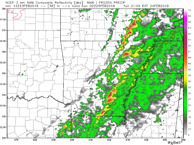
Later in the evening Saturday, around 9 PM, the storms are finally pushing through eastern Arkansas and out of the state completely in the early morning hours of Sunday. Notice how models try place the storms in a more linear style. However, even with simulated radar here you can see the cells still evolving into their own.
With lift present, and current guidance showing the winds turning with height, rotation and therefore supercell development is certainly possible. Model guidance has suggest the possibility for tall updraft formation, with storms that could back-build well into the atmosphere, thus leading to strong storms.
The grounds will already be heavily saturated due to the copious amounts of rainfall we have experienced. This will prove to be an issue as the storms will likely hold damaging winds, and even a tornado or two. Large trees could become uprooted and fall with ease, please keep this in mind.
-AW Team
Models used are accredited to: http://models.weatherbell.com/ - http://www.noaa.gov/


