
As a wave of low pressure moves east and southeast into this weekend, a strong area of storms is expected to develop Saturday afternoon. This could impact Arkansas in the same locations that have already seen copious amounts of heavy rainfall. At this current time, southeast Arkansas has the highest chances for more potent severe weather, this is obviously subject to change. This also DOES NOT mean other areas across the state will not see any severe weather. In fact, portions of central and southwest Arkansas could see some severe development Saturday.
A short wave in the mid-level atmosphere will slide through the upper level trough. A sub-tropical jet stream will help add a warm addition and needed moisture to the system. A warm front will nudge north and help surge warmer air from the Gulf, creating higher temperatures. Some storms will then build along the cold front into the evening and overnight as it progresses east.
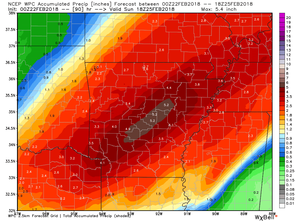
Models representing thunderstorms, instability values, temperatures, and rainfall amounts are posted below. The text below each model, and or graphic, represents the respective model posted above it.


The Storm Prediction Center, based in Norman, Oklahoma has issued a Marginal and Slight risk area for portions of the state. The southeast portion of the state is our target area for severe weather, but as we've stated, other areas could see organized severe weather Saturday; thus the large slight risk area.

We have posted the NAM 12-KM instability values Saturday afternoon (CAPE). You have seen us use models representing CAPE before, this is basically the "fuel" for thunderstorm development - Convective Available Potential Energy. Notice the abundant instability across eastern and southeast Arkansas, thus the reason for our target area. Although the instability values round out at around 1200-1500 J/kg, in the late winter months higher CAPE values are not needed for sufficient storm development (compared to the Spring season).

More organized storms should begin to track east around noon Saturday, mainly across western Arkansas. A few isolated areas of showers across eastern Arkansas are possible throughout the day, but nothing organized. The real show will start Saturday evening, we've posted a future-cast model above, valid for Saturday evening around 9 PM. Notice how the storms are bunched in a more linear form, this should limit tornado potential. However, an isolated tornado or two are certainly possible; our main concern is more heavy rainfall, strong damaging winds, and hail.
We will be monitoring Saturday throughout the next couple of days and have updates accordingly. The biggest story at this current time is by far the amount of rainfall, and flooding potential. It takes very little moving water to take a person off of their feet, this also includes vehicles. If you drive upon standing or moving water, TURN AROUND DO NOT DROWN.
We will likely have an additional blog post as we move closer to Saturday regarding the severe potential, stay tuned to our Facebook page and Twitter (@ARWeatherpage) as we provide updates.
-AW Team
All models used are accredited to: http://models.weatherbell.com/ - http://www.spc.noaa.gov/


