Wednesday, March 13, 2019

Severe Thunderstorms Possible Today

It's only Wednesday and it's already been a prolific week of weather here in the United States. A historic low pressure system currently tracking across our country has spawned severe weather including tornadoes across southwest, blizzard conditions, and flooding rains. It appears our turn for severe weather will arise later today. While we aren't completely sold on severe parameters here in Arkansas, the eastern sections of our state must be monitored closely.


As usual, first let's go over a few key points.

  • As of this morning (4:23 AM), there are currently storms on-going across central Texas and Oklahoma. These storms will eventually wonder into Arkansas later today.
  • Everyone has a fair shot at seeing some rainfall and a few storms out of this system, but the severe potential exists mainly across the eastern half of Arkansas.
  • While a tornado potential does exist, the main concern is damaging winds. But remember, damaging winds can be just as dangerous!
  • Areas east of Little Rock, especially into regions of our eastern borders appear favored for severe thunderstorms.

To enlarge the following graphics, especially if viewing on a mobile device, simply click on them to enlarge.


SPC day-1 outlook

The Storm Prediction Center has issued an enhanced risk of severe weather  for portions of eastern Arkansas. A slight risk has also been issued, which encompasses the enhanced risk.

30% Wind Probabilities 
We don't normally share graphics such as the one above. However, we felt this added to the point of the damaging wind risk for this afternoon. The SPC has issued a 30% risk probabilities for damaging wind gusts. Remember, severe winds are categorized as winds exceeding 58 mph or greater.

  
Southerly surface flow will aid in advecting warm/unstable air across eastern Arkansas and western Mississippi. As an approaching front tracks east, storms could strengthen. However, the warm sector doesn't appear all that impressive at this time. Nonetheless, thunderstorms could still have plenty of instability to work with and strengthen to severe limits.


By Wednesday afternoon, thunderstorms will be on-going across a large region. These storms should remain under severe limits, but a stray strong to severe storm cannot be ruled out. Remember, these storms will be moving into a move favorable environment across eastern Arkansas. 


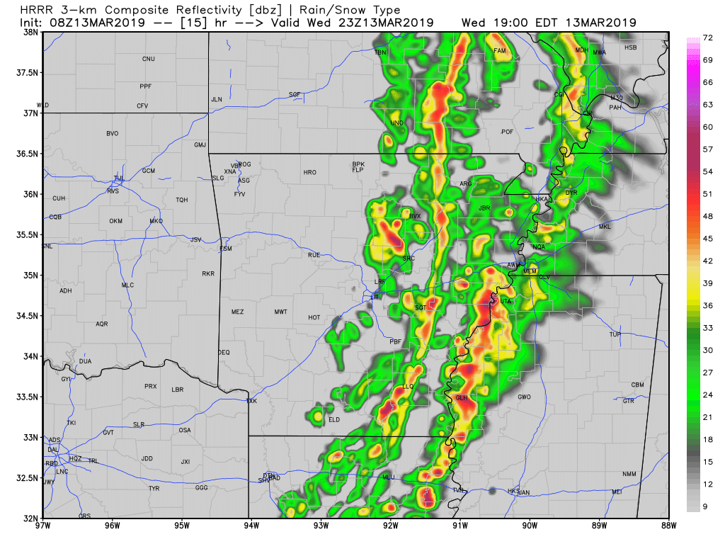
By Wednesday evening, storms are still on-going. We should begin to notice an uptick with the storm activity as it tracks into eastern Arkansas and western Mississippi. 


Continuing into Wednesday evening, storms could still be pestering portions of eastern Arkansas. However, this will be the last of the issues as storms continue to move east out of Arkansas Wednesday night.

Damaging wind gusts could be an issue, especially due to the heavily saturated grounds from our persistent rainfall. A tornado risk is present, but the dynamics simply don't support a widespread threat. Although, embedded tornadoes along the QLCS could occur, these are dangerous and generally occur quick! We'll have any warnings issued posted on Facebook. Follow our Twitter for updates as well.

-AW

Friday, March 8, 2019

Saturday Severe Weather

A turbulent start and finish for Saturday looks likely. Over the last 24 hours, we've been able to look at close range data and dial down some important details regarding severe weather chances for tomorrow. This blog will include a large amount of information, take a moment to read the following text as this could impact the weather where you live.


Let's go over a few key points for tomorrow.

  • It appears there will be two distinct rounds of severe weather tomorrow. An early morning round, involving mostly western Arkansas, and an afternoon round involving the eastern half of the state.
  • All modes of severe weather will be possible with both rounds, the afternoon round looking more significant than the morning round. 
  • By Saturday evening, we should be in the clear from any severe weather as it moves east out of Arkansas. 
  • One factor that could inhibit severe potential will be prior rainfall/storms during the morning hours. If significant convection does occur, it COULD dampen the severe potential across central/eastern Arkansas. 
  • Damaging winds, larger hail and an isolated or two is possible with any severe thunderstorm.

If you're viewing on a mobile device, you can simply enlarge the following graphics by clicking on them. 


Slight Risk Issued
A slight risk of severe weather has been issued for western Arkansas due to the potential of a late night/early morning round of severe weather. 

Enhanced Risk Issued
An additional enhanced risk of severe weather has also been issued for Saturday afternoon. A slight risk encompasses the rest of our state to account for any additional development during the afternoon hours.

During the overnight hours tonight, into the early morning hours of Saturday, warmer-moist air will nudge north. This warm sector will set the stage for thunderstorm development. The significance of this warm/unstable air moving north is important for thunderstorm development. For now, it appears the best chances will be across southwest Arkansas. Although thunderstorms could be widespread across western Arkansas. 


Following reference to the graphic above, we will likely wake up to stronger thunderstorms early on Saturday. While not all of these storms will be severe, some of them could be on the stronger side. Especially across southwest Arkansas. 


Fast forward to Saturday afternoon, we could notice an uptick in severe weather chances. A more prominent warm sector (warm/humid air) could aid in destabilizing our atmosphere. Notice the lack of instability across western Arkansas (no green/yellow colors).

By Saturday mid-day, thunderstorms will still be on-going. Some of the thunderstorm development could quickly strengthen as they move into a more favorable environment, specifically across eastern, northeastern Arkansas. Notice the HRRR simulated radar (above) is suggesting some isolated storm mode across northern/northeast Arkansas. This is concerning, as it could heighten a tornado threat. Just something to watch for now.


By Saturday afternoon, thunderstorms could still be on-going, but coming to an end here locally as they move east out of our state. 

Our primary area of concern is damaging winds and larger hail, with both rounds of severe weather. The afternoon round of storms could spawn a limited tornado threat, specifically across northeastern Arkansas where some finer dynamics appear more prevalent. Due to the potential of an early morning round of severe weather, it is a must that you have a way to receive warnings. Do NOT rely on outdoor warning sirens to wake you up.

Remain weather aware tomorrow, we'll have all warnings posted on our Facebook and will be updating on Twitter throughout the day.

-AW


Saturday, March 2, 2019

Sunday Snow

We have officially entered meteorological spring! However, nothing about this weekend resembles spring in any manner. Blustery cold and snow looks likely for Sunday across northern Arkansas, while a cold rain should persist elsewhere. Some of the snowfall could be heavy at times. This will likely cause travel issues on Sunday and some school closings for Monday.


  • We should begin to notice an uptick in isolated and spotty showers late Saturday into Sunday morning. A cold rain could initialize first across northwest Arkansas, but it won't last long. A mixture of sleet and snow will likely take over, before transitioning to all snow.
  • A persistent band of snow could track across northern Arkansas from west to east, before finally moving out Sunday afternoon. Some flurries could linger, before clearing completely Sunday evening.
  • Once the system exits, we will cool down drastically. Temperatures could dip into the single digits or low teens depending on snow pack. Dangerous wind chills could be an issue early Monday.
  • We wouldn't be surprised if a widespread 1-2 inches occur across northern Arkansas. However, some isolated areas could see 2-3 inches dependent on localized heavier banding of snow. This is difficult to forecast.
  • Some light flurries or sleet could mix into the rain across portions of the River Valley and central Arkansas. However, confidence in this is LOW, as temperatures simply look too warm.

Winter Weather Advisory 
The National Weather Service has already issued a winter weather advisory for the counties shaded in purple for Sunday. This advisory will expire at 6 PM on Sunday evening. This advisory will likely be expanded east, we will update accordingly on Facebook and Twitter.


Here is a simulated radar graphic for early Sunday morning. Notice isolated showers and maybe a few thunderstorms are on-going across southern Arkansas. A light winter mix (sleet/snow) will initiate first across far northwest Arkansas. You can clearly see the wide swath of snowfall to the northwest and north across Kansas and Missouri. 


Fast forward a few hours, the mix is still on going across NW Arkansas, but snowfall is beginning to take over. This will eventually spread east across northern Arkansas.


By Sunday mid-morning, most of northern Arkansas will be experiencing the expected snowfall. Notice the darker blue colors across north central Arkansas on this simulated radar graphic. Data is suggesting heavier banding, this could lead to those isolated higher amounts we've mentioned.


By Sunday evening, most of the winter weather activity will be east of Arkansas. Some isolated areas of flurries could linger, but most of the moisture will be gone.


Lastly, we leave you with our thoughts on snowfall accumulations. These sort of forecast graphics are always tough, as one small variable can drastically alter amounts. However, with what data we have, this our thought process. Northern Arkansas, specifically close to the Missouri border will likely see higher amounts. 

Travel conditions could be rough on Sunday, please be careful if you MUST drive. 

-AW

Winter Weather Possible Mid-Week

How awesome has the weather been today? After a nice taste of spring, reality will come crashing back by Tuesday evening. The entire state s...