Friday, February 22, 2019

Severe Weather for Saturday

Severe weather chances continue to trend in an upward manner for Saturday. Strong southerly surface flow will allow a warm front to extend north into the south central region of the United States. As this warmer air approaches the eastern half of Arkansas, cooler and dry air will extend east. This interaction, also known as a triple point, can be very dangerous. The Storm Prediction Center has placed most of eastern Arkansas into an "enhanced risk" of severe weather. While our goal is to never scare anyone, we want you to be informed and ready in case of inclement weather.


First, we'll go over a few bullet points.

  • Several regions could see some isolated showers or storms early on Saturday. This is NOT the storms associated with the severe weather risk. 
  • We could notice an uptick in stronger storm development, possibly severe, around lunch time Saturday.
  • As far as regional chances, areas east of Little Rock towards our eastern border appear most favored for any organized severe weather. If our state was split in half, the eastern half is the highlight zone. 
  • By Saturday evening, generally after 6-7 PM, the severe threat will have left our state. 
  • Cooler dry air will move in overnight Saturday, leaving us cool once again for Sunday morning.
  • All modes of severe weather are possible with this setup. Damaging winds, larger hail and tornadoes. While we aren't declaring an outbreak, a few of these tornadoes could certainly be stronger. 
  • Soil is highly saturated across eastern Arkansas. This could cause heightened flooding issues, as well as trees being knocked down during high winds. 

Saturday-Early Afternoon
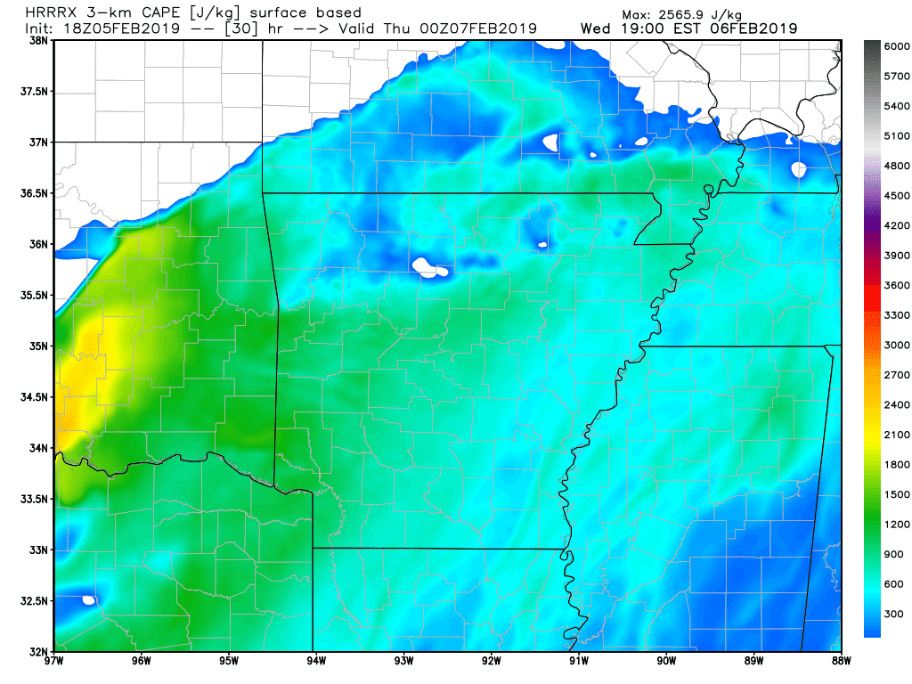
As mentioned above, warmer-moist air will push north as a warm front Saturday. This unstable air mass can easily be seen on this model posted above. Instability, measured in J /kg could possibly exceed values of 1800. While this is not unheard of, it is a higher observed value for February. Remember, instability is basically a measurement of the "fuel" for thunderstorms. Higher values can sometimes indicate the likelihood of stronger thunderstorm development.


By lunch time tomorrow, we could begin to see an uptick in stronger thunderstorms. As storms initialize and track into a more unstable air mass. 


Fast forward to around 2 PM, thunderstorms are on-going across our eastern border. The HRRR (model above) is suggesting a line, with broken thunderstorms. This is somewhat alarming, if thunderstorms can form into supercells and sustain their isolation, it could increase our tornado threat. Storms with a more linear complex normally inflict more of a damaging wind threat, rather than tornadoes.


By Saturday evening, most thunderstorm activity will have exited Arkansas to the east. 

Luckily, storm activity will be confined to the daylight hours. This is great for forecasters and media partners, as nocturnal storms can be even more dangerous. We said that to say this, even though this is a mid-day event do NOT let your guard down. Especially those of you across eastern Arkansas. Have a way to receive warnings and be careful! 

-AW


Tuesday, February 5, 2019

Dangerous Severe Weather

February is notorious for it's history of severe weather here in Arkansas. While most associate February with cold and snowy conditions, that is not always the case. We can't help but think back on February 5th, 2008, the "Super-Tuesday Outbreak". While we don't expect a storm event of that magnitude, we could deal with some dangerous severe weather Wednesday into early Thursday morning. We titled this blog "Dangerous Severe Weather" for a reason. It will not be anything we haven't seen before, however some thunderstorm activity could be nocturnal.

This aspect is always frightening for weather forecasters, as most will be sound asleep during severe weather. Assure that you have a proper way to receive warnings Wednesday night, a NOAA weather radio is a great start.

  • Southerly surface flow will continue to advect warm air north into Arkansas Wednesday. This warm moist air will set the stage by destabilizing our atmosphere. Temperatures will remain warm until a strong cold front sweeps the state on Thursday.
  •  It appears most of the expected severe thunderstorm activity should occur within the late afternoon into the evening hours of Wednesday. This could extend into the early morning hours of Thursday.
  • We will elaborate more below, but west central and northwest Arkansas seems to have the highest chances for severe weather.
  • All modes of severe weather will be possible, including damaging winds, larger hail and an isolated tornado or two. Heavy rainfall could also cause flash flooding issues late Wednesday night.
  • By mid-day Thursday, eastern and southwest Arkansas could still see some rainfall associated with this system. However, the severe threat will be diminished.
We have several model graphics below. Simply click on them to enlarge if some of the text is difficult to read. 

Slight Risk Area
A "slight" risk area has been issued by the Storm Prediction Center for portions of NWA, west central Arkansas and some of north central Arkansas. A marginal risk area is also in place for areas surrounding the slight risk. Just because you don't live in the slight risk area does not mean you won't see storm activity. This is simply the area highlighted with the best chances for severe thunderstorm development. 


Let's take a look at some CAPE. If you've read our blogs before, you've likely seen us mention "CAPE". CAPE, is the shortened term for convective available potential energy. In other words, a measurement of the present instability. Amounts here are not very high, although it does not take much CAPE during the winter months to produce stronger thunderstorms. Notice the higher amounts across eastern Oklahoma. 


By Wednesday afternoon, we could begin to see an uptick in storm activity. Some of these storms could initialize and remain isolated for some time. This COULD heighten the tornado threat, just something to watch for now.


By Wednesday evening, thunderstorms are still on-going. Some of these storms could also be severe. Notice some of the storm activity is still isolated.


By late Wednesday, into the early morning hours of Thursday, storm mode should switch to more linear. This will likely result in the all too familiar "squall" line type thunderstorm complex. Tornado threat will be limited, with more of a damaging wind threat along the gust front. This complex should weaken as it tracks east.

If you have any questions, feel free to comment or message. Thank you so much for reading and remember to share.

-AW

Winter Weather Possible Mid-Week

How awesome has the weather been today? After a nice taste of spring, reality will come crashing back by Tuesday evening. The entire state s...