Wednesday, December 11, 2019

Christmas Weather - More Snow Soon?

Every single year a follower, friend, or family member will ask me "will it snow on Christmas this year?" I don't mind the question, as a white Christmas is always welcome with most people. I'm here to tell you that I, nor anyone, knows if it will snow on Christmas day right now. I can provide you with the current weather data at hand. Speaking in regards of climatology, it is fairly rare here in Arkansas.

That being said, it isn't unheard of. Who else remembers the snowstorm of Christmas, 2012? There were BLIZZARD warnings issued across several Arkansas counties on Christmas day. Let's take a peak at the upcoming pattern.

River Valley snowfall (Jan 2019)
Over the course of this upcoming week, our weather pattern is fairly tranquil. Nothing extravagant and fairly seasonal conditions. That could change by the close of the weekend. We could even see some winter weather on Sunday and into Monday morning.


Please be aware, this isn't a forecast. It's just one model run - I'm only including it to portray the pattern change into the weekend. If the EURO solution verified (image above) some snowfall/winter mix could sneak into northwest/northern Arkansas on Sunday/Monday. The GFS model is less aggressive with this system, keeping the bulk of frozen precipitation north of Arkansas.

I feel like the EURO may be a bit aggressive, but this solution isn't uncommon given the time of year. Temperatures will likely be too warm elsewhere, leaving the higher elevations of northern Arkansas to deal with any frozen precipitation. 


To throw a kink into the mix, the latest 8-14 day temperature outlook actually favors above average temperatures across much of the country through Christmas Eve. This doesn't mean that cold air can't and won't occur, it's just based off the average. 


Just for fun, I've included the LONG range temperature data from the GFS on Christmas day. If this model verified (don't hold your breath); temperatures would be fairly different across Arkansas around mid-day. I should note that the GFS is depicting a cold front moving through Arkansas at this time, so temperatures would be much cooler by that evening. 

If you take anything from this blog, please understand that forecasting weather during this period of the year is very tough. I never go in-depth or attempt to confuse anyone. The verbiage and graphics above are plain and simple to understand. We will have a true idea on the weather pattern for Christmas as we get closer. 

For now, we'll keep an eye on this weekend and monitor the temperature trends. Thanks for reading! Don't forget to follow me on Twitter, I'll include my profile link below:


-Zach

Saturday, November 23, 2019

Thanksgiving Snow?

As we approach Thanksgiving, travel plans will begin to formulate among families across the country. Snowfall looks very likely across the midwest states on Wednesday of this week. Travel could be hazardous in this region, plan accordingly. As for us across the southern United States, what can we expect?


Temperature probabilities are actually favoring a warming trend over the 6-10 day period. With this being said, a strong shot of cold air looks likely mid-week across the southern plains. This could throw a kink in the above imaged forecast.


By mid-week (Wednesday) a powerful cold front could sweep across the southern plains. This would cool most of us significantly, as temperatures on Tuesday could range in the 60's and 70's across the southern U.S.


On Thanksgiving morning, a winter mix could occur behind the cold front. This is simply one model, but model trends have been consistent as of late. If this model verified, the bulk of the frozen precipitation would fall across regions of Kansas, New Mexico, the Texas panhandle and western Oklahoma before moving northeast.


For most of you, Thanksgiving could result in a raw and rainy day, as temperatures could hover in the low 40's. This appears most probable in Oklahoma and Arkansas, where temperatures will be simply too warm for any frozen precipitation.

As we approach closer, we will have any updated information posted on Facebook for our supporters. Please consider becoming a supporter, as it is very easy for us to connect with you during severe or inclement weather.

Remember to follow us on Twitter for more continuous updates: https://twitter.com/vortexchasing?lang=en

-Vortex Crew


Thursday, November 7, 2019

Snow in November? Could it be?

You've all heard the chatter about next week, the snow maps are flying here in Arkansas! I'm here to tell you that yes, it is possible. However, we all know VERY well how fast things can change. One thing is for sure, it's going to rain on Monday. The question is how long it will just be rain and not become a frozen form of precipitation.


Let's look over a few points of interest.

  • Monday morning could start off relatively mild for this time of year. Monday evening on the other hand, is a different story. Temperatures could fall quickly through the day behind a very powerful cold front.
  • Tuesday morning could be VERY cold, with temperatures in the teens across northern Arkansas.
  • Depending on how fast the moisture and cold air interaction occurs, some light snow/sleet could fall before the moisture exits our state.
  • This isn't a big snow or any sort of blizzard. We've seen this setup hundreds of times, it's just unusual for this time of year.

Here is a few model images from Weatherbell:


On Monday rain will likely be falling across much of the state by lunch time. Notice the widespread snowfall to our north and northwest.


By Monday evening, the cold air begins to seep south and the moisture could change over to light snow or some sort of winter mix. I will add that the EURO solution is fairly aggressive, I posted the GFS' take on this system on Twitter. As we get closer, close range models will likely have a more clear idea.


By Tuesday early morning, some light snow or a winter mix could occur across southeast/eastern Arkansas. Once again this may be a bit aggressive. 


Check out those temperatures on Tuesday morning! Pretty much everyone will be well below freezing, wind chills could be brutal early Tuesday as well. The cold is BY FAR the biggest story for now.

To finish off the blog, I would add that this is not an event to panic over. We all know very well the reality of 34 degrees and a cold rain. Northern Arkansas will certainly be favored for any winter weather chances Monday. Plan on being in school Tuesday, if things become more grim, I'll update all of you on Facebook and Twitter. 

Remember to follow me on Twitter too: https://twitter.com/wxzachary?lang=en

Thanks for reading!

-Zach

Wednesday, October 9, 2019

Fall? What Fall? More Thunderstorms on the way

The last few days have been great, low humidity and cooler temperatures; just what the doctor ordered. Tomorrow we will gradually warm up, it may actually be a little unpleasant tomorrow at times. Don't worry though, it won't last long. Fall will be a nice memory on Friday, as temperatures struggle to climb into the 60's. If you're reading this blog, you should also be following me on Twitter. If you haven't done that, please do so now! :)

https://twitter.com/wxzachary?lang=en (@wxzachary)


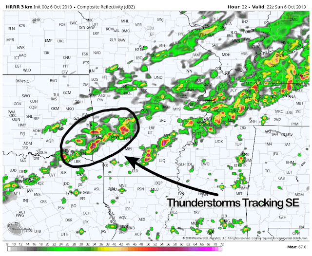
As usual with any prominent front, thunderstorms accompany. Most of Arkansas should actually avoid much of a "widespread" severe weather event. Better chances do exist across western Arkansas, however. I've included a simulated radar model below this text.


Storms will enter western Arkansas Thursday evening. While they move east they should weaken some, the better chances for widespread severe weather being east of Arkansas into Oklahoma.

The real story with this front is the cold snap we're about to experience. While it isn't anything unusual in Arkansas, the never-ending summer like conditions will be a point of joking conversation as we move into Saturday.


Saturday morning will be the coldest air we've experienced in a long time. While I do feel as if the data is a bit aggressive, I wouldn't be shocked to see frost reports across the higher elevations of northern Arkansas. Regardless, it's going to be cold out there.

I'll be out storm chasing in Oklahoma and western Arkansas tomorrow. If you have any questions, just let shoot me a comment or message! Thanks for reading.

-Zach

Saturday, October 5, 2019

Stronger Thunderstorms for Sunday

After a cool down on Friday, many of us warmed up again today. This pattern will be put on hold as another cold front is poised to move in on Sunday (tomorrow). As usual with a cold front, some thunderstorms are likely. Some of these mentioned storms could be stronger, maybe even severe criteria. In this blog I will cover that potential and who has the better chances to see any storms.

As we move into the fall season, winter and eventually spring, our weather patterns will ramp up at times. I constantly post updates on Facebook and Twitter. Please follow me on both sites, my Twitter handle is (@wxzachary) https://twitter.com/wxzachary?lang=en


Let's go over a few points.

  • A few storms are possible late tonight, especially across NWA. Most of these storms should remain under severe limits, but don't be surprised if you wake up to some thunder or heavy rain.
  • Temperatures and dew points ahead of the front will be warm and humid. By Sunday evening, there will be a noticeable drop in heat and humidity. Monday morning will be cool and dry, like Fall SHOULD be, Tuesday will be even cooler.
  • I fully suspect the strongest storms to occur across western sections of Arkansas, from I-40 south toward the Arklatex. Warm daytime heating and viable moisture should allow for sustained thunderstorm development ahead of the front.
  • While all modes of severe weather are possible, the main concern is damaging winds and larger hail. The tornado risk is not zero, but not high by any means.

I've included a few models to help paint a better picture.


If you've been following me for some time, you know I always like to include a model with the surface based CAPE values. I've done so here (model above this text). CAPE is essentially thunderstorm fuel, notice the higher values across southwest Arkansas, southeast Oklahoma and northeast Texas. This is due to warmer daytime heating and high moisture content. This combination is needed for sustained thunderstorm development.


By tomorrow afternoon it will be rather warm, especially across the southern half of Arkansas. You can clearly see the front positioned across northern Arkansas (50's and 60's) by tomorrow at lunch time. This won't last long, as the front will continue across the state during the span of Sunday evening.


By tomorrow afternoon, thunderstorms will be on-going across a fairly large part of the state. However, we will need to monitor the storms across southwest Arkansas as they form and track southeast. These are the storms I've been talking about in this blog and will pose the best threat for severe weather. 

There could also be a few other clusters of stronger storms across southern Arkansas as well. As I spoke on earlier, damaging winds and larger hail seems to be the biggest concern. This is not uncommon for October and it appears we will have more chances for severe weather in the not so distant future. 

Thank you so much for following and if you have any questions, feel free to comment or message! 

-Zach

Sunday, August 25, 2019

Severe Weather on Monday

Hey everyone! It's Zach from the Vortex Crew. As many of you know, I also storm chase locally for KNWA here in western Arkansas. It's been some time since I've worked on a severe weather blog, but it appears that drought will end tonight. We're expecting a strong round of thunderstorms on Monday evening. For now, it seems like portions of western Arkansas, specifically northwest Arkansas will see some of the strongest storm activity. Let's look at a few details!


  • Tomorrow will be warm and VERY humid. Excessive heat warnings have been issued for some counties locally. We should remain mostly dry throughout the day. 
  • Thunderstorms should form tomorrow to our northwest into Kansas and Missouri. These storms will form along a front and move southeast toward Arkansas.
  • I fully expect these storms to be fairly strong as they move into northwest Arkansas, where a rather unstable atmosphere will exist. 
  • All modes of severe weather will be possible, but I suspect damaging wind gusts and larger hail to be the main concern.


The Storm Prediction Center has issued an enhanced risk across much of Missouri and into northeast Oklahoma. A slight risk has also been issued to encompass this risk area. I wouldn't be the least bit surprised if the slight risk area is extended south to include more of western Arkansas.


By tomorrow evening, storms should be formed and well on their way southeast. Storms could be well matured by the time they arrive into northwest Arkansas. 


Fast forward and storms have entered northwest Arkansas, the complex stretching well across Missouri and even eastern Oklahoma. Mind you, this is simulated radar imagery and shouldn't be taken literally. Although, it does present a solid idea on what we could expect.


The last model I'd like to share is the CAPE, or convective available potential energy output. This represents what I like to term as "thunderstorm fuel". Warm humid air will aid in destabilizing our atmosphere tomorrow. This will allow for sustained thunderstorm development and track as storms enter NW Arkansas tomorrow. Notice those values within the purple and gray, anything over 2,500 j k/g is more than enough for strong to severe thunderstorm activity. 

Be sure to follow Dan, Melissa and Rick on KNWA and on social media. This blog is a basic detail regarding this event. I'll be out chasing storms tomorrow evening with plenty of updates on Facebook and Twitter. Follow me on Twitter! (@wxzachary).

-Zach


Tuesday, June 25, 2019

The Human Lightning Rod

In honor of National Lightning Safety Awareness Week, today's blog post is a little different that usual. On this day in 1977, Roy C. Sullivan entered the Guinness Book of World Records as the first person ever to be struck by lightning on seven different occasions. Yes, SEVEN different occasions.

Most lightning strikes survivedRoy Sullivan (1912-1983) was a park ranger at Shenandoah National Park for 36 years beginning in 1940. On seven different occasions between 1942 and 1977, six of them in the park, Ranger Sullivan was struck by lightning and lived to tell about it. Roy earned himself numerous nicknames such as "Dooms," "Sparky," "Human Lightning Conductor," and the "Human Lightning Rod." Though some doubt Sullivan's stories (no one ever witnessed any of the strikes, only the aftermath) Guinness World Records was able to verify them enough to award the ranger the "Most lightning strikes survived" title. Here are all 7 of his stories.

Strike 1

The first documented lightning strike of Sullivan occurred in April of 1942. He was hiding from a thunderstorm in a newly built fire lookout tower. Since the tower was newly built, a lightning rod was yet to be installed. During the storm, Roy said the tower was hit seven or eight times. Inside the tower, he says that “fire was jumping all over the place”. Sullivan ran out of the tower and just a few feet away received what he considered to be his worst lightning strike. It burned a half-inch strip all along his right leg, hit his toe, took off his toenail, and left a hole in his shoe.


Strike 2

Sullivan managed to make it 27 years before he was hit again in July 1969. Unusually, he was hit while in his truck and driving on a mountain road (the metal body of a vehicle normally protects people in cases such as this by acting as a Faraday cage). Sullivan says that lightning struck two trees on one side of the road, then jumped to another tree on the other side. Unfortunately, his truck was in the middle, with both windows rolled down. The strike knocked Sullivan unconscious and burned off his eyebrows and eyelashes, and set his hair on fire. The uncontrolled truck kept moving and nearly ran off a cliff edge.

Strike 3

In 1970, Sullivan was off-duty when he was in his front yard. He was tending to his garden when lightning hit a nearby power transformer then from there jumped to his left shoulder. Sullivan was knocked to the ground and received some minor burns.


Strike 4

In 1972, Sullivan was hit for the fourth time and sat on fire while working inside a ranger station in Shenandoah National Park. It set his hair on fire so he tried to smother the flames with his jacket. “There was a gentle rain, but no thunder, until just one big clap, the loudest thing I ever heard,” he said. “When my ears stopped ringing, I heard something sizzling. It was my hair on fire. The flames were up six inches.” He then rushed to the restroom, and used a wet towel to extinguish the flames. From that day forth, Sullivan always carried a pitcher of water with him in case his hair was set on fire.


Strike 5

On August 7, 1973, while he was out on patrol in the park, Sullivan saw a storm cloud forming and drove away quickly trying to outrun the storm. But the cloud, he said later, seemed to be following
him. When he finally thought he had outrun it, he decided it was safe to leave his truck. Big mistake. Soon after, he was struck by a lightning bolt. Sullivan stated that he actually saw the bolt that hit him. The lightning set his hair on fire, moved down his left arm and left leg and knocked off his shoe.


Strike 6

The next strike, on June 5, 1976, Sullivan injured his ankle. Sullivan was walking along a park trail when he saw a cloud, thought that it was following him, tried to run away, but was struck anyway. This was the final straw for ole Roy, so he retired five months later.

Strike 7


On Saturday morning, June 25, 1977, Sullivan was doing some trout fishing when lightning found him for the final time. The lightning hit the top of his head, set his hair on fire, traveled down, and burnt his chest and stomach. This bolt of lightning also caused Roy to lose hearing in one ear. Also, to top off "Lucky" number seven, Sullivan ran into a black bear on the way back to his car.


Image: Josh Pincus
In case you’re wondering, over the course of an 80-year life span, the odds of being hit by lightning are 1 in 3,000. The probability of being struck seven different times is 1 in 2,187,000,000,000,000,000,000,000.

I wish I had a happy ending to the Roy "Human Lightning Rod" Sullivan story, but I don't. On the morning of September 28, 1983, at the age of 71, Sullivan died from a self-inflicted gunshot wound over an unrequited love.

I hope you have enjoyed the blog post today and remember "when thunder roars, go indoors"

-Vortex Crew


Resources:

Lakeland Ledger - May 2, 1972

"The New York Times Archives: Roy Sullivan". September 30, 1983


Thursday, April 25, 2019

April 27th, 2011, Super Outbreak

When the date April 27th, 2011, is mentioned, the "Super Outbreak" immediately comes to mind. This outbreak of violent and deadly tornadoes was one for the record books. Starting on April 25th, lasting through the 28th, one of the deadliest and costliest tornado outbreaks occurred. While it isn't something to brag about, Alabama, Mississippi, Tennessee, Arkansas and Georgia charted numerous tornadoes over a 24 hour period, some very large and long lived. This volatile storm system produced over 300 tornadoes, ranging across the United States. Sadly, 348 people were killed due to the storms, Alabama alone saw 238 of those fatalities.

Large tornado moving through Tuscaloosa, Alabama.
This was no ordinary storm system, or chain of events. Some may forget that regions of Alabama, Mississippi and Tennessee observed a very dangerous and deadly round of storms early on the morning of April 27th, 2011. These storms crippled areas, leaving residents without power prior to the afternoon round of storms. Leading up to the afternoon hours, strong supercell storms formed in Mississippi before tracking east. This was only the beginning of a long day of severe weather across the south.

Supercell track of the deadly "Tuscaloosa/Birmingham tornado".
Throughout the day, notable tornadoes occurred across a wide region. Some of those tornadoes include: the Neshoba County, Mississippi tornado (EF-5), Enterprise, Mississippi (EF-4), Smithville, Mississippi (EF-5), Cullman, Alabama (EF-4), Hackleburg, Phil Campbell, Mount Hope, Tanner and Harvest, Alabama (EF-5/killed 72 people), Reform, Oakman, Cordova, Blounstville, Alabama (EF-4), Pisgah, Flat Rock, Higdon Alabama and Trenton Georgia (EF-4), Bridgeport Alabama and Haletown, Tennessee (EF-4), Ohatchee, Piedmont Alabama and Cave Spring, Georgia (EF-4) and lastly the Tuscaloosa/Birmingham, Alabama (EF-5).


This blog is being produced thanks to Tornado Safety Shelter Systems Inc. If you're in need of a storm shelter, give them a call at 501-941-1005. The staff would love to answer any questions you may have. For a discount on any product, give the code "Vortex".

Large wedge tornado approaching Tanner, Alabama (EF-5)
April 27th, 2011, was a truly incredible day (on a meteorological scale). Very rarely do you ever see numerous large and destructive tornadoes in one day. In fact, tornadoes are rare, very few storms ever actually produce a tornado, let alone a violent or large one. The fine details, or meso-scale features as it's called, were off the charts. If you haven't seen the video footage of James Spann and Jason Simpson covering this event, we would highly advise for you to watch it. Their work saved the lives of many people on this day. Not only them, but everyone in the broadcast/warning field from the area.

Below is a interview style video with James Spann, of ABC 33/40. Take a moment to watch as James gives his thoughts on this grim day.


April 27th, 2011, will NEVER be forgotten. Rest in peace to those who lost their life during these ferocious storms.

This blog has been brought to you by Tornado Shelter Safety Systems Inc.

-Vortex Crew

Credits:

(Brian Lang (supercell track), University of Alabama skycam.


The Future of Storm Shelters - Vortex Vault!

If you have been following us for awhile, you would know that we don't normally advertise for companies or just any product. This has changed recently, as we've now partnered with Tornado Shelter Systems Inc. Our goal as storm chasers is to document severe weather, as well as provide proper and accurate warning information for areas involved. But what happens after that warning? Some heed to those warnings and seek shelter, while others pop popcorn and watch their local news station.


The hard truth is that these storms can hurt, or even worse, kill you. Severe weather kills people every single year in the United States. Why not make the investment and purchase a product that can protect you and your family during inclement weather situations. We recently posted on our Facebook a quick preview of the "Vortex Vault" from Tornado Shelter Systems Inc. This thing is absolutely incredible! If you're still scratching your head, watch the video below. You won't regret it!


The Vortex Vault is truly monumental for the future of safety during severe weather events. If you choose to forego the Vault, Tornado Shelter Systems Inc. has plenty of other options for you and your family. We've included a few photographs of those products below.

Vortex Vault
Above ground shelter and Vortex Vault

Above ground shelter


Hopefully you enjoyed the quick look at the wonderful products this company has to offer. Don't wait until it's too late, call now for a quote, or any questions you may have. Be sure and mention the code "Vortex" for a discount!

This blog has been brought to you by Tornado Shelter Systems Inc.

Thank you all for reading!

-Vortex Crew

Thursday, April 11, 2019

Dangerous Severe Weather for Saturday

As we move into the mid-portion of April, severe weather chances normally increase for most regions of the southern United States as well as the southern plains. This normality seems apparent this weekend, as a very dynamic and potent system could allow for some strong to severe thunderstorm development across the southern United States. Mind you, this is nothing none of us haven't experienced before. The point of this blog is to prepare you, the reader, for the events that could unfold over the weekend.

Tornado that occurred in Louisiana (2017) 
Leading into this weekend, a few key components will occur that could allow for the mentioned severe thunderstorms to develop. While looking at upper-air maps, it's clear that our jet stream will deep well into the southern tier of the United States. A strong deepening negative tilted trough, along with a viable low-level jet, and plentiful warm air advection will set the stage for convective development Saturday. 

Deepening trough extending well into the southern United States

Notice in the graphic directly above this text, you can clearly see the warm southerly advection from the Gulf into regions of eastern Texas and Louisiana. This WAA will allow for a rather unstable warm sector, with CAPE values easily exceeding 2,000 J/kg. Essentially, thunderstorms will have no issues developing and strengthening in this moisture-rich environment. 


Adding to the most previous information, here is a look at the low-level jet (850mb) for Saturday. Notice a substantial increase over north central Louisiana, eastern Texas and southern Arkansas with well over 50 knot flow.

Day-3 Categorical Outlook from the Storm Prediction Center
As of Thursday, April 11th, at 2:00 PM, the Storm Prediction Center has outlined portions of southern Arkansas and north central Louisiana in an "enhanced risk" of severe weather. While a "slight" risk area has been issued encompassing a large region. 

Significant Tornado Parameters for Saturday
Looking over the STP parameters for Saturday, it looks grim. Mind you, this isn't to scare you or install panic. Rather, we hope it gives you an idea of the atmospheric conditions for this weekend. When storms enter an environment that allows that needed "spin", it can allow for these all too familiar rotating thunderstorms. Notice values are high across the areas we've mentioned several times. 

To round off this blog, we'll cover a few key points for Saturday. Areas in southern Arkansas, northern Louisiana and eastern Texas need be prepared for severe weather on Saturday. Widespread thunderstorms will likely develop, some which could be stronger. All modes of severe weather are possible. This includes: damaging winds, large hail and a few tornadoes (some which could be stronger).

Have a way to receive warnings, NEVER depend on outdoor 1940's era sirens to alert you of an incoming tornado warned storm. NOAA weather radios, social media and your local news affiliate is a much better and sensible option.  

Please follow us on Facebook and Twitter (@VortexChasing) for updates regarding this weekend system.

-Vortex Crew


Wednesday, March 13, 2019

Severe Thunderstorms Possible Today

It's only Wednesday and it's already been a prolific week of weather here in the United States. A historic low pressure system currently tracking across our country has spawned severe weather including tornadoes across southwest, blizzard conditions, and flooding rains. It appears our turn for severe weather will arise later today. While we aren't completely sold on severe parameters here in Arkansas, the eastern sections of our state must be monitored closely.


As usual, first let's go over a few key points.

  • As of this morning (4:23 AM), there are currently storms on-going across central Texas and Oklahoma. These storms will eventually wonder into Arkansas later today.
  • Everyone has a fair shot at seeing some rainfall and a few storms out of this system, but the severe potential exists mainly across the eastern half of Arkansas.
  • While a tornado potential does exist, the main concern is damaging winds. But remember, damaging winds can be just as dangerous!
  • Areas east of Little Rock, especially into regions of our eastern borders appear favored for severe thunderstorms.

To enlarge the following graphics, especially if viewing on a mobile device, simply click on them to enlarge.


SPC day-1 outlook

The Storm Prediction Center has issued an enhanced risk of severe weather  for portions of eastern Arkansas. A slight risk has also been issued, which encompasses the enhanced risk.

30% Wind Probabilities 
We don't normally share graphics such as the one above. However, we felt this added to the point of the damaging wind risk for this afternoon. The SPC has issued a 30% risk probabilities for damaging wind gusts. Remember, severe winds are categorized as winds exceeding 58 mph or greater.

  
Southerly surface flow will aid in advecting warm/unstable air across eastern Arkansas and western Mississippi. As an approaching front tracks east, storms could strengthen. However, the warm sector doesn't appear all that impressive at this time. Nonetheless, thunderstorms could still have plenty of instability to work with and strengthen to severe limits.


By Wednesday afternoon, thunderstorms will be on-going across a large region. These storms should remain under severe limits, but a stray strong to severe storm cannot be ruled out. Remember, these storms will be moving into a move favorable environment across eastern Arkansas. 


By Wednesday evening, storms are still on-going. We should begin to notice an uptick with the storm activity as it tracks into eastern Arkansas and western Mississippi. 


Continuing into Wednesday evening, storms could still be pestering portions of eastern Arkansas. However, this will be the last of the issues as storms continue to move east out of Arkansas Wednesday night.

Damaging wind gusts could be an issue, especially due to the heavily saturated grounds from our persistent rainfall. A tornado risk is present, but the dynamics simply don't support a widespread threat. Although, embedded tornadoes along the QLCS could occur, these are dangerous and generally occur quick! We'll have any warnings issued posted on Facebook. Follow our Twitter for updates as well.

-AW

Friday, March 8, 2019

Saturday Severe Weather

A turbulent start and finish for Saturday looks likely. Over the last 24 hours, we've been able to look at close range data and dial down some important details regarding severe weather chances for tomorrow. This blog will include a large amount of information, take a moment to read the following text as this could impact the weather where you live.


Let's go over a few key points for tomorrow.

  • It appears there will be two distinct rounds of severe weather tomorrow. An early morning round, involving mostly western Arkansas, and an afternoon round involving the eastern half of the state.
  • All modes of severe weather will be possible with both rounds, the afternoon round looking more significant than the morning round. 
  • By Saturday evening, we should be in the clear from any severe weather as it moves east out of Arkansas. 
  • One factor that could inhibit severe potential will be prior rainfall/storms during the morning hours. If significant convection does occur, it COULD dampen the severe potential across central/eastern Arkansas. 
  • Damaging winds, larger hail and an isolated or two is possible with any severe thunderstorm.

If you're viewing on a mobile device, you can simply enlarge the following graphics by clicking on them. 


Slight Risk Issued
A slight risk of severe weather has been issued for western Arkansas due to the potential of a late night/early morning round of severe weather. 

Enhanced Risk Issued
An additional enhanced risk of severe weather has also been issued for Saturday afternoon. A slight risk encompasses the rest of our state to account for any additional development during the afternoon hours.

During the overnight hours tonight, into the early morning hours of Saturday, warmer-moist air will nudge north. This warm sector will set the stage for thunderstorm development. The significance of this warm/unstable air moving north is important for thunderstorm development. For now, it appears the best chances will be across southwest Arkansas. Although thunderstorms could be widespread across western Arkansas. 


Following reference to the graphic above, we will likely wake up to stronger thunderstorms early on Saturday. While not all of these storms will be severe, some of them could be on the stronger side. Especially across southwest Arkansas. 


Fast forward to Saturday afternoon, we could notice an uptick in severe weather chances. A more prominent warm sector (warm/humid air) could aid in destabilizing our atmosphere. Notice the lack of instability across western Arkansas (no green/yellow colors).

By Saturday mid-day, thunderstorms will still be on-going. Some of the thunderstorm development could quickly strengthen as they move into a more favorable environment, specifically across eastern, northeastern Arkansas. Notice the HRRR simulated radar (above) is suggesting some isolated storm mode across northern/northeast Arkansas. This is concerning, as it could heighten a tornado threat. Just something to watch for now.


By Saturday afternoon, thunderstorms could still be on-going, but coming to an end here locally as they move east out of our state. 

Our primary area of concern is damaging winds and larger hail, with both rounds of severe weather. The afternoon round of storms could spawn a limited tornado threat, specifically across northeastern Arkansas where some finer dynamics appear more prevalent. Due to the potential of an early morning round of severe weather, it is a must that you have a way to receive warnings. Do NOT rely on outdoor warning sirens to wake you up.

Remain weather aware tomorrow, we'll have all warnings posted on our Facebook and will be updating on Twitter throughout the day.

-AW


Winter Weather Possible Mid-Week

How awesome has the weather been today? After a nice taste of spring, reality will come crashing back by Tuesday evening. The entire state s...