Monday, April 30, 2018

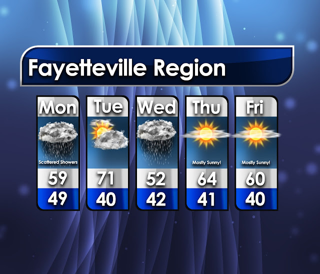
5-Day Regional Forecast

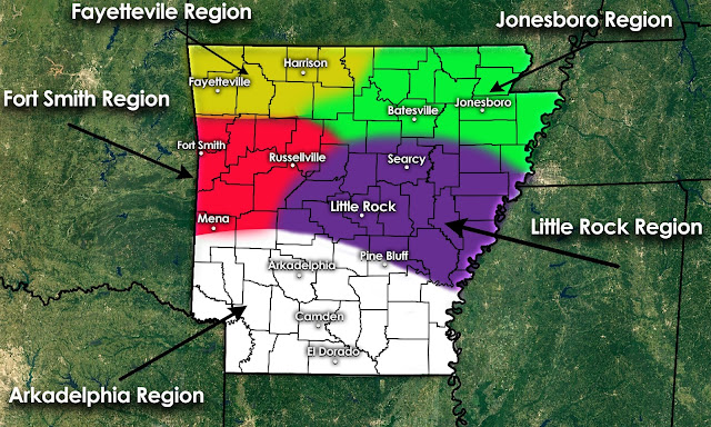
Hello and welcome to our 5-day Regional Forecasting! This is a new series of forecasting that we hope we can branch out and apply to all of our followers. Since we do not have a "market" or certain region we cover, forecasting for the entire state can be sometimes tough. We hope to simplify this by placing different areas into regions. We have created a 5-day outlook for each region, and have those outlooks posted below. This will NOT be perfect and we knew it wouldn't be prior to creating this. However, each region will have it's own forecast, and we are confident that these forecasts will be accurate to your area.

If you look at our outlook map and notice you are very close to two different regions, be mindful that the temperatures could be slightly different than the outlook posted. That being said, there should not be a huge difference among the outlook regions. A great example of this if you live in northern Crawford County. You are placed in our "Fort Smith" region, but you can likely expect slightly cooler temperatures than the Fort Smith region since you are placed further north.

We hope you enjoy these outlooks and find them helpful as you attempt to plan your week! If these outlooks are popular and remain accurate as we expect them to be, we will continue them!
Regional Outlook Areas
Below we have posted the individual outlooks. We have named each region with a notable city as a tag for the region. We thought this would create a more simplistic way for everyone to identify the region they reside in.


Click one of the following four boxes for further information.


-AW Team

Thursday, April 26, 2018

Signals of a Storm Brewing

It wouldn't be early May without a few stronger storms across the southern United States would it? We are currently in a quiet weather pattern, with beautiful weather in store for this weekend. Sunny skies with temperatures in the mid 70's will be the headlines. A much needed relief after our last several weekends being down right nasty! As we mentioned in a recent Facebook post, the honeymoon period will be short lived. There are growing signs of severe weather possible across the southern US, and this could ultimately include Arkansas. We are still in the long range regarding this next setup. With this being long range, things will alter within the forecast. However, a blog post now giving everyone a quick heads up never hurt anyone.

  • An area of strong low pressure will begin churning across the central United States throughout the next week. As it moves eastward it will bring a long all sorts of nasty weather. Snow over the Rockies, heavy rainfall, severe weather, and yes this could include some tornadoes.
  • The real question is just how significant it will be. We've been watching this for several days now, and the picture is gradually becoming more clear. NOBODY knows what will happen exactly, and if they say they do they are not being honest.
  • It looks as if Arkansas could get their first taste of this mess on Wednesday. Beyond that, it is a little muddy for much detail.
  • Very unstable energy will be present Wednesday, this has been agreed upon by both of our longer range models. This could lead to some stronger thunderstorm development Wednesday afternoon/evening.
  • Coverage of the storms, and just how widespread they will be is still up for discussion. This matter will be resolved once we are closer to the weather event itself.

Low pressure over the central United States.
A strong trough will develop over the western sides of the United States early next week. As this strong area of deep low pressure begins to churn and track east, it will be accompanied by all sorts of nasty weather. For those weather nerds out there, it does appear this trough will hold a more "negative tilt". What does this mean you may ask?

Negative tilting of a trough is a sign that areas of low pressure have reached maturity. This also indicates strong differential advection, also substantial increasing of thermodynamic instability. So, we have an area of deep low pressure, negatively tilting of the trough, and a warm/moist sector combination east of the Rockies. This usually leads to widespread severe weather, something we have experienced throughout time.

Higher CAPE values across central Oklahoma
Things will begin to ramp up Monday for portions of far western Oklahoma. However, this should occur well away from Arkansas and will not involve us at all. Then we move on to Tuesday, we have posted a graphic above showing the unstable energy present over central Oklahoma. Notice CAPE values climbing during the afternoon/evening hours. However, the storms that do develop during Tuesday should lose their steam before making it into Arkansas Tuesday night. This is something will we watch closely.

GFS CAPE Wednesday 
So when does this batch of storms move into Arkansas, and will they be severe? Looking into Wednesday this is by far our best chances for now. With dew points increasing, temperatures climbing into the mid to upper 70's (possibly 80's), and a substantial short wave trough, stronger storm coverage will increase. This could lead to development of strong thunderstorms throughout the afternoon and evening. Just how far east these storms will track is still a question. We'll know more on the issue of who is involved, and who isn't once we get closer. 

Storm Prediction Center Outlook
As this blog is being produced (4-26-18 3:31 PM) the Storm Prediction Center has a 15% outlook posted regarding severe weather in their 7-day outlook. This does include a small portion of western Arkansas. This outlook will likely be expanded to a wider coverage area of the state. Remember, we are still 7-days away, outlooks are hardly ever issued regarding severe weather this far out. 

We are still leaning towards the idea that central and western Oklahoma look to hold higher chances for a more potent severe weather event. However, we must be careful as these storms track east into our state. Once we get closer we will have our own outlook graphics, risk areas, and more detailed forecasts. Currently, Oklahoma has not experienced a tornado in 2018, while Arkansas has experienced 22. Stay tuned!

-AW Team

Model use accredited to: http://models.weatherbell.com/


Sunday, April 22, 2018

5-Day Regional Forecasts

Hello and welcome to our first week of 5-day Regional Forecasting! This is a new series of forecasting that we hope we can branch out and apply to all of our followers. Since we do not have a "market" or certain region we cover, forecasting for the entire state can be sometimes tough. We hope to simplify this by placing different areas into regions. We have created a 5-day outlook for each region, and have those outlooks posted below. This will NOT be perfect and we knew it wouldn't be prior to creating this. However, each region will have it's own forecast, and we are confident that these forecasts will be accurate to your area.

If you look at our outlook map and notice you are very close to two different regions, be mindful that the temperatures could be slightly different than the outlook posted. That being said, there should not be a huge difference among the outlook regions. A great example of this if you live in northern Crawford County. You are placed in our "Fort Smith" region, but you can likely expect slightly cooler temperatures than the Fort Smith region since you are placed further north.

We hope you enjoy these outlooks and find them helpful as you attempt to plan your week! If these outlooks are popular and remain accurate as we expect them to be, we will continue them!

Regional Outlook Areas
Below we have posted the individual outlooks. We have named each region with a notable city as a tag for the region. We thought this would create a more simplistic way for everyone to identify the region they reside in.


-AW Team

Saturday, April 21, 2018

Rainy Weekend Ahead

Welcome to our newest blog! This is a special blog for us, as it includes our first video forecast. This is something we have never done, and something we hope to build on for the future. We hope you enjoy, and find this video to be informative. We like the idea of doing video forecast due to us being able to fit a large amount of information into a short video (under 10 minutes). You can view this video below:


In conclusion, this weekend looks very wet! We've posted the rainfall total model again for reference. Keep the umbrella and rain jacket handy!


-AW Team

Model graphic and use accredited to: http://models.weatherbell.com/

Sunday, April 15, 2018

Winter Won't Go Away - More Severe Weather?

After the wild weekend of severe weather, we are glad to announce that this week looks fairly quiet regarding any severe weather. In fact, there isn't much rain in the forecast. With a ridge of high pressure in place the severe weather/snow storms will be pushed off well to our north. A large trough of cold air will dig into the central portion of the country early this week. This will give way to very cold, and non-Spring like temperatures for us early Monday morning. The next severe weather threat looks to take place next weekend. This is still long range and there is a ton of model disagreement, which is to be expected being this far out. As of right now, it does not appear to be anything like this most recent event.

Thanks to an area of high pressure we will remain mostly dry this week. With a few chances of very light rain showers around Thursday. With this in place cloud cover will be somewhat limited, giving us beautiful weather for the most part.

A large trough of very cold arctic air will dig south, this will lead to VERY chilly temperatures Monday morning (4-16-18). Notice in the graphic above the arrow pointing out the red and blues lines. This is indicative of the freezing line, this line moves well into Arkansas, giving way to below freezing, or just above freezing temperatures for most of us. Check out the strong area of low pressure in the northeast part of the country (red L near Pennsylvania). This is the same area of low pressure that has brought all the snow to the north, and severe weather across the south we just experienced.


If you thought this morning was cold, just wait until tomorrow morning. It is going to be absolutely frigid in northern Arkansas, with temperatures in the 20's. We've taken the model data from the NAM 3-km and implemented them in the graphic above. They may be a little overestimated, but regardless this is very cold air for mid-April. 

The real issue for tomorrow morning is the wind chill. The air temperatures will be cold enough, adding in strong gusty winds will make this even worse. Some of northern Arkansas could experience wind chill readings in the mid teen's. This will make the Monday morning commute very chilly, bundle up!

Our next severe weather event looks likely next weekend
Looking into the long range, or voodoo country as it is coined in the meteorological field, things begin to get interesting again. Next weekend it appears a warm front will lift northwards into Arkansas on Saturday. However, a cold front will crash the party as it moves east. With some unstable air present (graphic posted above) this could spark a few storms, some possibly stronger.

It is far too early for any sort of specifics, but it is Spring and worth mentioning. This could always fizzle out and we could just see a few thunderstorms. Parameters don't look off the charts regarding this and we do NOT expect it to be anything like our most recent severe weather event. We'll keep an eye on it though.

-AW Team

Model use accredited to: http://models.weatherbell.com/

Thursday, April 12, 2018

Potential For Dangerous Severe Weather

You've read all the scary posts this week, and seen all the graphics, simulated radar images, etc. We're closing in on Friday the 13th, and unfortunately severe weather does look likely for some of us. But don't panic! We will make it through this together, and be perfectly fine. Always remember if severe weather is possible, have a simple plan to protect yourself and your family. Find the safest, most interior place inside your home, away from windows. Helmets are great to place on you, or your children's head. Another great way to protect yourself during imminent severe weather is to place a mattress over yourself. These are just a few ways to protect yourself from dangerous severe weather. Weather radios are great as well in-case of outages.

Earlier this week we posted the graphic below regarding the severe weather possible for tomorrow afternoon/evening. Our thinking has not altered much since we created this. However, there are a few variables that could sway the weather tomorrow, so pay close attention throughout this blog as this system seems to be fairly complex. We are going to try and give you the best timing and placement for tomorrow to help aid you plan ahead properly. 


  • A strong area of low pressure to our northwest will began its progression east throughout the next couple of days. This is the culprit to the powerful storm system set to bring severe weather and heavy snowfall for a large portion of the United States over the next few days.
  • Scattered rain showers will develop tomorrow morning and continue throughout most of the day. These showers could have a few embedded thunderstorms, but should remain under severe limits for the most part.
  • These pre-frontal showers could help aid in stabilizing the atmosphere tomorrow, lowering the overall severe threat. We are crossing our fingers for this, if we had sunny skies throughout the day this entire event would be a whole different story (big tornadoes).
  • There could be some severe development during the mid-afternoon, but we are confident that most severe weather shouldn't initiate until the evening hours (after 5 PM). This is great, especially regarding the school hours for children. 
  • Tomorrow evening as the dry line approaches western Arkansas a very unstable warm sector will began to track east sparking strong thunderstorms - some severe and possible supercelluar.
  • Models have went back and forth on where exactly these storms will begin to fire, and we may not know this until it actually gets here. This is the reason we highlighted the entire western section of Arkansas in red.
  • Some of us may NOT see any severe weather at all. Remember that statement, as we have stated these stronger storms could be isolated rather than a large line of storms like we usually see. Especially across far western Arkansas as this will be a developmental zone for thunderstorms.
  • Eventually, thunderstorms will form into a large complex and track east, finally exiting the state to the east early Saturday morning. This is a good thing, as this will help lower the tornado threat.
Unstable atmosphere tomorrow evening
We have included the surface based CAPE model above, to help better explain the reason for the stronger thunderstorms. CAPE is basically the fuel needed for thunderstorm development. As you can see, the western half of Arkansas will have a plentiful amount of energy to work with for storm development tomorrow evening. We've included an arrow on the right side of the graphic pointing to the scale reading. Notice there are areas exceeding 3,300 J k/g, which is more than enough instability for stronger storm development. This energy does die off some as the system progresses east, thus our reason for leaving eastern Arkansas at lower chances for more widespread severe weather. 

Our target area for isolated tornadoes
After looking over model data for the last couple of days, and this morning, we have included a graphic above for our target area for isolated tornadoes. This does NOT mean other places will not see any tornadoes, or severe weather for that matter. However, we feel this highlighted area has the best chances due to supercell composites and helicity values. The circled area above will need to be watched very close during the afternoon/evening hours tomorrow until the threat has moved east.

Simulated radar example of isolated thunderstorm development
Tomorrow evening there will likely be a large complex of thunderstorm moving east. This is to be expected, and these storms could hold some severe potential of it's own. However, our main focal point will be isolated cell development on the backside of the large complex. We have circled an example in the above posted model data. These individual cells will hold a higher tornado threat and could become supercelluar as they initiate along the dry line in the unstable air mass (explained above). Until these storms form into a larger complex we will need to be on a higher alert for tornadoes due the isolated nature of the cells.  

Supercell composite for tomorrow evening
Supercell composites are not off the charts for tomorrow, but there is certainly plenty of energy to work with. We like using composites because we can fit a large amount of information into one model itself, helping better explain the situation at hand. We didn't post this in hopes of scaring anyone, but rather it help show you the environment will be amplified tomorrow evening. Notice the higher values across southwest Arkansas (our target area).

Storm Prediction Center outlook for tomorrow (Friday, April 13th)
Lastly, we leave you with the Storm Prediction Center outlook for tomorrow (April 13th). A large majority of Arkansas is currently under an enhanced risk of severe weather. There could be an upgrade to a moderate risk (level 4) by tomorrow, likely for western, and southwest Arkansas. Remember, just because your area is not at risk for stronger tornadoes does not mean you could not experience severe weather. Eastern Arkansas is included in this graphic due to the nature of the storms as they move east. These storms could hold a damaging hail, and damaging wind threat. 

Key points in conclusion:

- Rainy day Friday regardless of any severe weather
- Some of the stronger storms may not be as widespread, but for those who do see development severe warnings will be likely.
- Best chances are in the late afternoon/evening. 
- Western and southwest Arkansas have the highest chances for isolated tornadoes.
- Flash flooding could become an issue, especially in eastern Arkansas during large storm complex. 

-AW Team

Model use accredited to: http://www.spc.noaa.gov/products/outlook/day2otlk.html - http://models.weatherbell.com/


Tuesday, April 10, 2018

Spring Severe Season 101 - Tornadoes

With the Spring severe season quickly approaching, we know some may wonder further into the realm of severe weather. We've all sat down and watched our local news station, waiting to hear our town to be called for the next warning during severe weather events. But have you ever wondered further into the wild nature of severe weather? Severe weather can be quite complex, one small change can create a large scale difference in a single storm. This week we will be covering tornadoes - a well known severe weather phenomenon that occurs every single year in Arkansas.


Large tornado that occurred in Chicot County in 2008


The Science Behind the Desctruction


A tornado is a violently rotating column of air descending from a thunderstorm while in contact with the ground. Although tornadoes are usually brief, lasting only a few minutes, they can sometimes last several hours and cause extreme damage or even worse, death. Tornadoes are the #3 most hazardous aspect of thunderstorms (#2 is lightning) while flash flooding is #1. 

Most tornadoes are spawned from supercellular thunderstorms. Supercell thunderstorms are characterized by a persistent rotating updraft and form in environments of strong vertical wind shear. Wind shear is the change in wind speed or direction with height. Directional wind shear is the change in wind direction with height.

As the elevation increases the direction veers, becoming south, then southwest, and finally, west. Speed shear is the change in wind speed with height. In the illustration below, the wind is increasing with height. Strong vertical shear is the combination of a veering directional shear and strong speed shear and is the condition that is most supportive of supercells involving tornadoes.

The funnel cloud of a tornado consists of moist air. As the funnel descends to the ground the water vapor within it condenses into small liquid droplets. The liquid droplets are identical to cloud droplets, yet they are not considered part of the cloud since they form within the funnel itself. The descending funnel is made visible because of the water droplets. The funnel takes on the color of the cloud droplets, which is white. Due to the air movement, dust and debris on the ground will begin rotating, often becoming several feet high and hundreds of yards wide.

After the funnel touches the ground and becomes a tornado, the color of the funnel will change. The color of the tornado often depends on the terrain, or debris it collects while on the ground. Tornadoes can last from several seconds to more than an hour but most last only minutes.

Tornado Ratings


Tornado ratings on the enhanced Fujita Scale


When a possible tornado passes through your community, your National Weather Service coverage office will be there to inspect the damage. You can often see them out and about, observing property damage, looking for possible tracks, and doing their own research. This is crucial for us to learn more of tornadoes, and severe weather in general.

Tornadoes are rated by damage rather than size, or how scary they might look. In fact, there could be a large tornado that is rated lower than a tornado that may appear smaller in stature. The key to rating a tornado involves the damage it causes. Tornadoes are ranked on the enhanced Fujita Scale from the lowest tier (EF-0) to the most powerful and deadly (EF-5). Arkansas has only experienced one tornado that reached the rating of an EF-5. This was the "Sneed" tornado, which occurred in 1929 in northeastern Arkansas.

Below are several photos of tornadoes that have occurred in Arkansas:

Tornado that occurred in Hampton (Calhoun County)

EF-3 tornado that occurred in north central Arkansas during the super-Tuesday outbreak of February 5th, 2008.

Rope tornado that occurred near Grady (Lincoln County)
Photo credit: Stas Speransky 
Mayflower/Vilonia tornado (2014)
Large tornado during the Super Tuesday Outbreak
Photo credit: Ty Graham
Large tornado from Wynne (Cross County)

We hope you enjoyed this entry into our Spring severe season 101 blogs. We hope you learned something new, and have a better understanding of tornadoes and severe weather in general. Thank you for reading!

-AW Team


Sunday, April 8, 2018

Spring Trying To Settle In - More Severe Weather This Week

We've had an interesting last few days to say the least, freezing temperatures and snowfall covering the ground. It is almost mid-April and most of us had iced over windshields this morning. Some more Spring like weather is on it's way however. We have a few more cool mornings before we gradually warm up. At the end of the week we'll have a possibility for some stronger thunderstorms ahead of a cold front. Some of the storms could certainly hold some severe potential, especially across western Arkansas.

  • Most of us woke up to temperatures in the 30's this morning, with wind chills in the low 30's and high 20's. This is not common, we are well below average for April.
  • For Monday, Tuesday, Wednesday and Thursday we will gradually creep warmer each day. It looks like the best chance for rain will be northern Arkansas later today (Sunday) with a chance for an isolated shower or two.
  • Once we arrive at Friday we will experience much more Spring like temperatures throughout the day with most of us reaching low to mid 70's.
  • A cold front will progress east towards Arkansas Friday evening, eventually moving through Friday night into early Saturday.
  • As this cold front moves east thunderstorms will form a long the front. This is still considered long range, but models have been consistent with showing plenty of unstable energy for storms to work with (read further below). 

Very chilly morning (4-8-18)
It is very non-spring like this morning, with most of us at or below freezing. Northern Arkansas is experiencing wide spread temperatures in the 20's, with wind chills nearing the teens. We made a post on Facebook awhile back regarding not planting yet, this was what we were talking about! See, we aren't crazy after all.


There is a chance of rainfall today (Sunday) and tomorrow (Monday). The best chances exist for today, mostly across northern Arkansas. Notice the snow showers across southern Missouri, it will be close, but we should be too warm for any snow. However, we've been wrong before and you never know what could happen. 

Warm temperatures Friday (4-13-18)
Now, Friday of this upcoming week is still considered long range talk, but models have been consistent with southerly flow from the gulf, thus raising temperatures and ushering in warm moist air. It will feel MUCH more Spring like during the late week period.

Our target areas for late week severe weather
With much warmer air, and plentiful moisture (mid-60 dew points), the environment will be somewhat amplified prior to the expected cold front Friday evening. It appears the strongest storm production could miss us just to the west in Oklahoma. However, western Arkansas will still have plenty of instability to work with as storms move east along the front. We do expect the storms to die off gradually as they move east into a less unstable environment. That being said, central Arkansas could certainly see their fair share of stronger storms. 

The storm prediction center has caught onto the model data as well, already highlighting a 15% risk area for most of the state for their day-6 convective outlook. This is not uncommon, as we are entering our peak season for severe weather. It is a little early for specifics, but all modes of severe weather will be likely. We'll have updates throughout the week regarding this system.

-AW Team

Model use accredited to:  http://models.weatherbell.com/


Wednesday, April 4, 2018

Winter Weather Possible - More Severe Thunderstorms

Prepare yourself, this blog is a long one. We have a large amount of information to cover regarding the weather pattern for the next few days. As most of you know, here in Arkansas we know of no such thing as "normal" weather. We usually experience a roller coaster of patterns, and that phrase is best exemplified for this weekend. First of all, severe weather chances look possible again. After that, temperatures will cool off again leading to a chance of some winter weather. We have our doubts, but we can't ignore the data we are looking over.

  • For the remainder of today (Wednesday) we will remain nice and dry, with cooler temperatures. 
  • We will warm gradually Thursday, but remain fairly cool in some areas. We do have a chance of some showers Thursday, but it is not a wash out and no major amounts are expected by any means.
  • Friday is the day things begin to get interesting. A warm front will lift northwards, elevating temperatures into the mid 70's (mostly the southern half of the state). Friday evening a cold front will begin to track south. This clash of air masses will spark thunderstorms Friday evening into the late night hours.
  • EVERYONE will likely see rainfall as the cold front moves south. Regardless if you see any winter weather or severe storms, this is something we can guarantee. 
  • Some of the storm development could hold a severe potential, mostly across the southern half of Arkansas (south of I-40).
  • Once the cold front sweeps the state, and the storms have moved off, we will cool down substantially. Some of our model data has indicated temperatures dropping to as low as the mid 20's Saturday morning (northern Arkansas).
  • With residual moisture still at hand, and widespread colder air (below freezing) we could experience some winter weather throughout Friday night into early Saturday morning. We will eventually warm back above freezing Saturday mid-day.
Temperatures Friday evening
There will be a drastic temperature contrast Friday evening for the entire state. Notice the sharp gradient along the cold front in northern Arkansas. However, the southern half of the state is still warm, with temperatures in the mid 70's across southern Arkansas. As the colder air moves south, thunderstorms will develop along the front. 

Southern Arkansas is our target area for storms Friday night
As mentioned above, temperatures will warm into the mid 70's Friday. Along with the temperature increase, low level moisture will rise into the mid 60's. This combination will help destabilize the atmosphere and prep the environment for thunderstorm development. Our target area is the southern half of Arkansas, where instability is the highest (CAPE values nearing 2,700 J/kg). 

Simulated radar image late Friday night (NAM 12-km)
Simulated radar (late Friday evening) places a large complex of storms, likely in a linear fashion along the front moving south. Due to the likelihood of these storms forming into a line it will aid in diminishing the tornado threat. However, larger hail and damaging straight line winds will be possible, especially along the frontal zone of the storms. 

Very cold temperatures Saturday morning (NAM 12-km)
So then we fast forward several hours, and we've arrived to early Saturday morning. The EURO, GFS, and NAM model all agree that we could experience well below freezing temperatures Saturday morning. However, the key will be where that line of freezing air stops. Notice the gradual decrease and increase of temperatures along and north of I-40. This temperature difference will be key in who sees any winter weather (if we see any at all).


Now for the grand finale, whats the story on the winter weather. To precursor all of the following information, we all know how difficult it is to forecast winter weather. This situation is no different, and things will change from now (Wednesday 9:53 AM) until late Friday. HOWEVER, models have been showing this chance for a few days, and continue to do so this morning. 

As the front settles in Friday night we will drop to at or below freezing in certain areas, mainly north of I-40. Where this freezing line occurs and sets up, and where the most residual moisture is available, will make all the difference in who sees any winter weather, and how much. This is NOT a big event and we don't expect any major accumulation if any with this event. 

With that being said, there could certainly be roadway issues early Saturday morning depending on how much wintry weather falls. We could experience all sorts of winter weather, freezing rain, light snow, or some sleet. The next question is just how far this freezing air will move south, and the honest answer is we don't know. Nobody knows this, we just have an idea, stemming from the model data we have at hand. This will be a fluid forecast and things will change, the winter weather possibilities could dissipate completely, so be prepared for that (snow lovers).

If you read this entire blog, thank you so much and we hope this cleared up any speculation for this weekend. We will have updates on our Facebook/Twitter leading up to the event itself. 

-AW Team

Model use accredited to: http://models.weatherbell.com/

For further information regarding weather where you live, click one of the following four boxes below.


Monday, April 2, 2018

Thunderstorms Tuesday - Some Possibly Severe

Good morning everyone, hopefully you all had a fantastic Easter weekend, and are all rested up for the week! After a cooler day yesterday, and today, we will warm up quickly Tuesday making it feel MUCH more Spring like. The cold however will come fighting back, cooling us back down for the mid-week. Due to the quick warm-up and then sharp moving cold front Tuesday, this could mean thunderstorms, some possibly strong to severe.

  • We could warm up to near 80 degrees Tuesday afternoon, especially across southern and eastern Arkansas. These warmer temperatures will help aid in day-time convection for thunderstorm development. 
  • Dew points will be somewhat elevated, with readings near 70 in certain areas. This muggy low level moisture will also aid in thunderstorm development. 
  • Eventually, a cold front will progress southeastward towards Arkansas later in the day Tuesday. Along the edge of this cold front we should start to see thunderstorm development.
  • Some of the storms that do develop could be stronger, especially across southern and eastern Arkansas where the highest instability is located. 
  • Time frame looks to be around 4 PM and after, eventually the cold front will progress entirely through the state diminishing storm chances early Wednesday morning.

Our target area for possible severe weather Tuesday (4-3-18)
In the graphic placed above we have highlighted our target area for the most LIKELY severe weather development. Portions of NWA could see a few thunderstorms, but instability is lacking in this area. Latest model guidance has suggested plenty of CAPE (fuel for thunderstorms) across central, southern, eastern, and even northeastern Arkansas for Tuesday. With day time temperatures climbing into the 70's and plentiful moisture, this will induce an unstable atmosphere Tuesday afternoon. 

Temperatures mid-day Tuesday
Temperatures will be in the mid-70's to near 80 in some areas mid-day Tuesday. Notice the cold front to the northwest, this is the front responsible for our storm chances.

Super cell Composite Parameter
We've included the supercell parameters model for this event to help portray the target area we've posted above. Supercell parameters are a basic representation regarding the ingredients needed for supercell development. This is NOT to scare anyone, rather just show everyone the atmosphere will be amplified Tuesday, which could lead to some stronger storms.

Simulated radar image for Tuesday afternoon (NAM 3KM)
Storms should began to develop in the afternoon hours of Tuesday. We are confident in the idea of these storms being more linear in nature, forming into a squall line of thunderstorms. These storms will move southeast in correlation with the cold front.

Simulated radar image for Tuesday evening (NAM 3KM)
By Tuesday evening the storms are still on-going, but have progressed southeast. Notice the models are suggesting the storms will continue to hold strength.

Simulated radar image for early Wednesday morning (NAM 3KM)
Finally, the storms will exit the state as the cold front moves through the entire state. Notice the 32 degree in southern Missouri edging close to northern Arkansas. It could be fairly cold early Wednesday after the front has made its way through.


Lastly, we've included our risk graphic for this event. The Storm Prediction Center has kept most of the eastern half of Arkansas in a "slight" risk area for Tuesday. Stronger storms are possible, and some could possibly be severe. The main threats included damaging winds, larger hail, and some isolated tornadoes. These tornadoes would likely be weaker, and form as smaller spin-up tornadoes along the frontal zone of the squall line. However, we must remain diligent and treat every storm with respect! 

-AW Team 

Model use accredited to: http://models.weatherbell.com/

For further weather information, you can click one of the four boxes below.


Winter Weather Possible Mid-Week

How awesome has the weather been today? After a nice taste of spring, reality will come crashing back by Tuesday evening. The entire state s...