
Here is what you can expect!
- At 6:00 AM this morning we are setting at temperatures around 60 to 70 degrees. This will change drastically with portions of the state being in the 30's by around midnight tonight.
- Showers and storms are already under way this morning, these storms will continue through Wednesday due to a slow moving low pressure system.
- Some of the storms associated could be on the strong side, however we don't expect widespread severe weather - instability is limited.
- There COULD be some freezing rain possible (NWA) as the cold front nudges into the state, this would occur late tonight into the early morning hours of Wednesday (2-21-18). Some slick spots could certainly be possible, but nothing widespread. Much higher ice totals will remain west of Arkansas (thankfully).
- Flooding could become an issue due to the excessive rainfall, especially in areas that are not experiencing drought conditions. We will update on this matter accordingly, flash flood watches have been already been issued for portions of the state.
Below are models posted showing temperatures, winter weather chances, and thunderstorm possibilities.
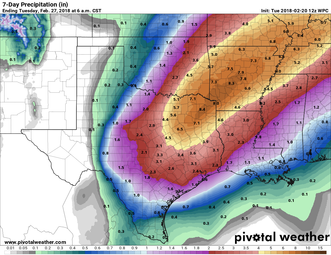 |
| QPF model courtesy of Pivotalweather.com |
We've posted the 7-day QPF amounts, notice some areas could see near 8 inches of rain. This model should be taken lightly, as rainfall amounts could vary. Regardless, it's going to be wet and rainy for awhile, flash flooding could certainly be possible.
 |
| Major temperature contrast late tonight |
Temperatures are currently warm, with 60's and 70's throughout the state. However, this will change as a cold front creeps from the west. Notice portions of northwest Arkansas will be in the low 30's late tonight, while areas in southeast Arkansas are still above 70!

Storms are possible throughout the day, instability does look limited at this time. With that being said some stronger storms could certainly develop, especially across southeast and eastern Arkansas later tonight. The biggest story this week is by far the rainfall amounts and potential for flooding issues.
 |
| Light freezing rain amounts |
There is a possibility for freezing rain to develop as the cold front progresses through the state. Portions of extreme northern, and northwest, Arkansas could see this changeover late tonight into the early morning hours of Wednesday. Amounts look fairly light, a few slick spots could develop early Wednesday. Travel could be hazardous anyhow due to heavy rains and wet roads, so use caution.

***NERD ALERT***
This last graphic may look completely outlandish to some of you, but for those weather geeks out there you will notice it quickly! If you look at the area circled on the Skew-T you can really see the "warm nose" in the lower area of the atmosphere. This supports the area of freezing rain expected across NWA tonight. You can see around 1000MB the temps are well below freezing, while the atmosphere around 850MB is slightly above freezing - a classic freezing rain setup. Luckily, amounts do appear light and shouldn't cause too much of a headache!
-AW Team
All models used are accredited to: Pivotalweather.com and Weatherbell.com.


